| << Deutschland: Historische Karten und Stadtpläne (im Bereich der heutigen Bundesrepublik) << Rockstuhl |
||
|
||

Zuletzt angesehene Artikel:
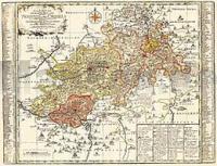
 | Vogtland - Neustädtische Kreis und die Ämter Arnshaugk, Miltenfurth, Weyda 1757 - Historische Landkarte Nachdruck Planokarte - gerollt von Schenk, Peter - Verlag Rockstuhl |
 | 18-4 Cabo de Ajo Amtliche topographische Landkarte 1:25.000 Spanien (M.T.N.) 18-4 Mapa Topográfico Nacional de Espana (MTN25) Instituto Geográfico Nacional - CNIG Spanien |
 | 3932 09 Njuohkarggu Topographische Karte 1:20.000 (Maastokartta / Peruskartta / Grundkarta) Maanmittauslaitos / Lantmäteriverket Finnland - ProjektNord |
 | 4511 06 Huokausvaara Topographische Karte 1:20.000 (Maastokartta / Peruskartta / Grundkarta) Maanmittauslaitos / Lantmäteriverket Finnland - ProjektNord |
 | 332-1 VIC Amtliche topographische Landkarte 1:25.000 Spanien (M.T.N.) 332-1 Mapa Topográfico Nacional de Espana (MTN25) Instituto Geográfico Nacional - CNIG Spanien |
 | 329-2 SANT CLIMENÇ Amtliche topographische Landkarte 1:25.000 Spanien (M.T.N.) 329-2 Mapa Topográfico Nacional de Espana (MTN25) Instituto Geográfico Nacional - CNIG Spanien |
 | 912-3 MULA Amtliche topographische Landkarte 1:25.000 Spanien (M.T.N.) 912-3 Mapa Topográfico Nacional de Espana (MTN25) Instituto Geográfico Nacional - CNIG Spanien |
 | 91-3 QUINTO REAL Amtliche topographische Landkarte 1:25.000 Spanien (M.T.N.) 91-3 Mapa Topográfico Nacional de Espana (MTN25) Instituto Geográfico Nacional - CNIG Spanien |
 | 107-2 BRAÑOSERA Amtliche topographische Landkarte 1:25.000 Spanien (M.T.N.) 107-2 Mapa Topográfico Nacional de Espana (MTN25) Instituto Geográfico Nacional - CNIG Spanien |
 | 195-4 SANTA CRISTINA DE VALMADRIGAL Amtliche topographische Landkarte 1:25.000 Spanien (M.T.N.) 195-4 Mapa Topográfico Nacional de Espana (MTN25) Instituto Geográfico Nacional - CNIG Spanien |
 | 423-4 ALMENDRA Amtliche topographische Landkarte 1:25.000 Spanien (M.T.N.) 423-4 Mapa Topográfico Nacional de Espana (MTN25) Instituto Geográfico Nacional - CNIG Spanien |
 | 765-2 LA GINETA Amtliche topographische Landkarte 1:25.000 Spanien (M.T.N.) 765-2 Mapa Topográfico Nacional de Espana (MTN25) Instituto Geográfico Nacional - CNIG Spanien |
 | Wschowa (Fraustadt) Stadt und Gemeinde - Stadtplan 1:15.000 und Touristische Landkarte 1:50.000 Wanderkarte, Radwanderkarte, Freizeitkarte Wschowa miasto i gmina mapa TopMapa Pietruska & Mierkiewicz - Polen |
 | 3732 05 Sokka-Voutavaar Topographische Karte 1:20.000 (Maastokartta / Peruskartta / Grundkarta) Maanmittauslaitos / Lantmäteriverket Finnland - ProjektNord |
 | 3812 12 Maarestatunturi Topographische Karte 1:20.000 (Maastokartta / Peruskartta / Grundkarta) Maanmittauslaitos / Lantmäteriverket Finnland - ProjektNord |
 | 3713 10 Aihkipalonaapa Topographische Karte 1:20.000 (Maastokartta / Peruskartta / Grundkarta) Maanmittauslaitos / Lantmäteriverket Finnland - ProjektNord |
 | Woronesch Stadtplan 1:36.000 - Russland Воронеж - Карта города Rus Co. Ltd. |
 | 3323 05 Niemiskylä Topographische Karte 1:20.000 (Maastokartta / Peruskartta / Grundkarta) Maanmittauslaitos / Lantmäteriverket Finnland - ProjektNord |
 | 927-3 JIMENA Amtliche topographische Landkarte 1:25.000 Spanien (M.T.N.) 927-3 Mapa Topográfico Nacional de Espana (MTN25) Instituto Geográfico Nacional - CNIG Spanien |
 | 246-2 ORÉS Amtliche topographische Landkarte 1:25.000 Spanien (M.T.N.) 246-2 Mapa Topográfico Nacional de Espana (MTN25) Instituto Geográfico Nacional - CNIG Spanien |