| << Deutschland: Historische Karten und Stadtpläne (im Bereich der heutigen Bundesrepublik) << Rockstuhl |
||
|
||

Zuletzt angesehene Artikel:
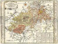
 | Vogtland - Neustädtische Kreis und die Ämter Arnshaugk, Miltenfurth, Weyda 1757 - Historische Landkarte Nachdruck Planokarte - gerollt von Schenk, Peter - Verlag Rockstuhl |
 | 1011 05 Lågskär Topographische Karte 1:20.000 (Maastokartta / Peruskartta / Grundkarta) Maanmittauslaitos / Lantmäteriverket Finnland - ProjektNord |
 | 6120 Obernburg am Main Topographische Landkarte Bayern 1:25.000 - Normalausgabe - ProjektNord (geplottete Ausgabe) - Grundlage amtliche Topographische Karte Bayern DTK25 |
 | 711-4 EL ROBLEDILLO Amtliche topographische Landkarte 1:25.000 Spanien (M.T.N.) 711-4 Mapa Topográfico Nacional de Espana (MTN25) Instituto Geográfico Nacional - CNIG Spanien |
 | 1109 Playa del Inglés - Gran Canaria Amtliche topographische Landkarte 1:50.000 Spanien (M.T.N.) 1109 Mapa Topográfico Nacional de Espana (MTN50) Instituto Geográfico Nacional - CNIG Spanien |
 | 2814 08 Kaamusjärvi Topographische Karte 1:20.000 (Maastokartta / Peruskartta / Grundkarta) Maanmittauslaitos / Lantmäteriverket Finnland - ProjektNord |
 | 3413 12 Käkilahti Topographische Karte 1:20.000 (Maastokartta / Peruskartta / Grundkarta) Maanmittauslaitos / Lantmäteriverket Finnland - ProjektNord |
 | Oblast Donezk 1:250.000 Geographische StraĂźenkarte 1:250.000 Donezka oblast Sahalnogeografitschna Karta / Донецька область Kartografija - ukrmap Ukraine |
 | 3331 11 Siilinjärvi Topographische Karte 1:20.000 (Maastokartta / Peruskartta / Grundkarta) Maanmittauslaitos / Lantmäteriverket Finnland - ProjektNord |
 | Tschita - Chabarowsk - Wladiwostok StraĂźenatlas Russland 1:100.000 Chita - Habarovsk (M-58) Habarovsk - Vladivostok (M-60) Atlas avto dorog - Russland |
 | 64-3 Villabona Amtliche topographische Landkarte 1:25.000 Spanien (M.T.N.) 64-3 Mapa Topográfico Nacional de Espana (MTN25) Instituto Geográfico Nacional - CNIG Spanien |
 | 104-2 REYERO Amtliche topographische Landkarte 1:25.000 Spanien (M.T.N.) 104-2 Mapa Topográfico Nacional de Espana (MTN25) Instituto Geográfico Nacional - CNIG Spanien |
 | 518-1 UTRILLAS Amtliche topographische Landkarte 1:25.000 Spanien (M.T.N.) 518-1 Mapa Topográfico Nacional de Espana (MTN25) Instituto Geográfico Nacional - CNIG Spanien |
 | 2312 11 Kortesjärvi Topographische Karte 1:20.000 (Maastokartta / Peruskartta / Grundkarta) Maanmittauslaitos / Lantmäteriverket Finnland - ProjektNord |
 | 703-2 ARROYO DE LA LUZ Amtliche topographische Landkarte 1:25.000 Spanien (M.T.N.) 703-2 Mapa Topográfico Nacional de Espana (MTN25) Instituto Geográfico Nacional - CNIG Spanien |
 | 2533 01 Santosenkari Topographische Karte 1:20.000 (Maastokartta / Peruskartta / Grundkarta) Maanmittauslaitos / Lantmäteriverket Finnland - ProjektNord |
 | 59-3 SELAYA Amtliche topographische Landkarte 1:25.000 Spanien (M.T.N.) 59-3 Mapa Topográfico Nacional de Espana (MTN25) Instituto Geográfico Nacional - CNIG Spanien |
 | 4822 07+10 Nammivaara Topographische Karte 1:20.000 (Maastokartta / Peruskartta / Grundkarta) Maanmittauslaitos / Lantmäteriverket Finnland - ProjektNord |
 | 3413 11 Vaivaissuo Topographische Karte 1:20.000 (Maastokartta / Peruskartta / Grundkarta) Maanmittauslaitos / Lantmäteriverket Finnland - ProjektNord |
 | 776-3 TALAVERA LA REAL Amtliche topographische Landkarte 1:25.000 Spanien (M.T.N.) 776-3 Mapa Topográfico Nacional de Espana (MTN25) Instituto Geográfico Nacional - CNIG Spanien |