Willkommen bei MapFox
Wurde Ihre Bestellung bestätigt? Wenn nicht - gab es evtl. ein SERVER-Problem! Bitte kontaktieren Sie uns! +++ Buchhändler-Anfragen erwünscht +++
Warenkorb
Artikel: 0 - € 0.00
Zur Kasse
Impressum Kontakt Versandkosten AGB
Polen: Topographische Karte 1:25.000 System 65
<< zurück

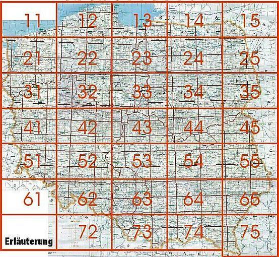
Bitte klicken Sie auf die gewünschte Region!
HINWEIS: Die dicken braunen Linien geben die 1:100.000 Blattschnitte wieder. diese teilen sich in 4x 1:50.000 oder 16x 1:25.000.

Erläuterung zu den Blattschnitten (wird in einem neuen Browserfenster geöffnet)

Zuletzt angesehene Artikel:

Cover4313 03 Kantelejärvi Topographische Karte 1:20.000 (Maastokartta / Peruskartta / Grundkarta) Maanmittauslaitos / Lantmäteriverket Finnland - ProjektNord

Cover0529-1 ARMENTEROS Topographische Landkarte 1:25.000 Spanien (Grundlage MTN25) Instituto Geográfico Nacional - CNIG Spanien - ProjektNord

Cover0555-3 NAVARREDONDA DE GREDOS Topographische Landkarte 1:25.000 Spanien (Grundlage MTN25) Instituto Geográfico Nacional - CNIG Spanien - ProjektNord

Cover122-1 VILA DE CRUCES Amtliche topographische Landkarte 1:25.000 Spanien (M.T.N.)
122-1 Mapa Topográfico Nacional de Espana (MTN25) Instituto Geográfico Nacional - CNIG Spanien

Cover1107-I San Bartolomé de Tirajana - Gran Canaria Amtliche topographische Landkarte 1:25.000 Spanien (M.T.N.)
1107-I Mapa Topográfico Nacional de Espana (MTN25) Instituto Geográfico Nacional - CNIG Spanien

Cover0491-4 CAMINREAL Topographische Landkarte 1:25.000 Spanien (Grundlage MTN25) Instituto Geográfico Nacional - CNIG Spanien - ProjektNord

Cover2142 07 Päilahti Topographische Karte 1:20.000 (Maastokartta / Peruskartta / Grundkarta) Maanmittauslaitos / Lantmäteriverket Finnland - ProjektNord

Cover3513 08 Hetekylä Topographische Karte 1:20.000 (Maastokartta / Peruskartta / Grundkarta) Maanmittauslaitos / Lantmäteriverket Finnland - ProjektNord

Cover605-1 ILLESCAS Amtliche topographische Landkarte 1:25.000 Spanien (M.T.N.)
605-1 Mapa Topográfico Nacional de Espana (MTN25) Instituto Geográfico Nacional - CNIG Spanien

Cover4231 01+04 Närsäkkälä Topographische Karte 1:20.000 (Maastokartta / Peruskartta / Grundkarta) Maanmittauslaitos / Lantmäteriverket Finnland - ProjektNord

Cover4124 04 Särkisalmi Topographische Karte 1:20.000 (Maastokartta / Peruskartta / Grundkarta) Maanmittauslaitos / Lantmäteriverket Finnland - ProjektNord

Cover0641-1 CASTELLÓ DE LA PLANA Topographische Landkarte 1:25.000 Spanien (Grundlage MTN25) Instituto Geográfico Nacional - CNIG Spanien - ProjektNord

CoverNL 32-03-20 Ost (2220-Ost) Stanzach Österreichische Karte 1:25.000 mit Wegmarkierungen (topographische Wanderkarte - UTM) - BEV - Österreich - Vergrößerung (ÖK25V)

Cover3322 01 KUONA Topographische Karte 1:20.000 (Maastokartta / Peruskartta / Grundkarta) Maanmittauslaitos / Lantmäteriverket Finnland - ProjektNord

Cover3243 05 Kurjala Topographische Karte 1:20.000 (Maastokartta / Peruskartta / Grundkarta) Maanmittauslaitos / Lantmäteriverket Finnland - ProjektNord

Noch kein Cover vorhanden1121 Medelby - Gestern und Heute - Historische Überlagerung 1932-1950 Topographische Landkarte 1:25.000 im Vergleich - Landesvermessungsamt Schleswig-Holstein / ProjektNord

Cover0676-1 MORTERA Topographische Landkarte 1:25.000 Spanien (Grundlage MTN25) Instituto Geográfico Nacional - CNIG Spanien - ProjektNord

Cover0686-2 TURLEQUE Topographische Landkarte 1:25.000 Spanien (Grundlage MTN25) Instituto Geográfico Nacional - CNIG Spanien - ProjektNord

Cover767-1 ALATOZ Amtliche topographische Landkarte 1:25.000 Spanien (M.T.N.)
767-1 Mapa Topográfico Nacional de Espana (MTN25) Instituto Geográfico Nacional - CNIG Spanien

Cover1058-1 EL EJIDO Topographische Landkarte 1:25.000 Spanien (Grundlage MTN25) Instituto Geográfico Nacional - CNIG Spanien - ProjektNord