| << Österreich: Amtliche topographische Wanderkarten 1:50.000 (UTM-Gitter) des BEV - ÖK50 |
  | |
|
||
Zuletzt angesehene Artikel:
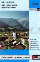
![]() | NL 33-01-19 (3219) Neukirchen am Großvenediger Österreichische Karte 1:50.000 mit Wegmarkierungen (topographische Wanderkarte - UTM) - BEV - Österreich |
![]() | 6133 Muggendorf Topographische Landkarte Bayern 1:25.000 - Normalausgabe - ProjektNord (geplottete Ausgabe) - Grundlage amtliche Topographische Karte Bayern DTK25 |
![]() | 3211 Lähden *** SCHNÄPPCHEN *** Amtliche topographische Karte 1:25.000 Landesvermessungsamt Niedersachsen |
![]() | 822 (30-32) Benissa Amtliche topographische Landkarte 1:50.000 Spanien (M.T.N.) 822 Mapa Topográfico Nacional de Espana (MTN50) Instituto Geográfico Nacional - CNIG Spanien |
![]() | 3854 Vogelsang (Eisenhüttenstadt Ost) Sonderausgabe mit Wanderwegen - Topographische Wanderkarte Brandenburg 1:25.000 ProjektNord |
![]() | 587 S. Bartolomeu De Messines (Silves) Topographische Landkarte Wanderkarte und Fahrradkarte Portugal 1:25.000 587 Mapa topográfico - Mapa de caminhadas - Portugal 1:25.000 ProjektNord |
![]() | 433 Topographische Landkarte Wanderkarte und Fahrradkarte Portugal 1:25.000 433 Mapa topográfico - Mapa de caminhadas - Portugal 1:25.000 ProjektNord |
![]() | 3142-NO Topographische Karte 1:10.000 - Landesvermessungsamt Brandenburg |
![]() | 0729-3 RINCÓN DE BALLESTEROS Topographische Landkarte 1:25.000 Spanien (Grundlage MTN25) Instituto Geográfico Nacional - CNIG Spanien - ProjektNord |
![]() | Grönland 1:7.1 Mio. Landkarte Grönland Saga Maps Kalaallit Nunaat - Grønland |
![]() | 1 II Arcos de Valdevez Topographische Landkarte Portugal 1:50.000 Carta Militar de Portugal Instituto Geográfico do Exército (IGeoE) - Portugal |
![]() | 441-B - Topographische Landkarte Portugal 1:25.000 Carta Militar de Portugal - Série M888 Instituto Geográfico do Exército (IGeoE) - Portugal |
![]() | 970 Huelma Amtliche topographische Landkarte 1:50.000 Spanien (M.T.N.) 970 Mapa Topográfico Nacional de Espana (MTN50) Instituto Geográfico Nacional - CNIG Spanien |
![]() | 4722 Niederzwehren - Wanderkarte mit Wanderwegen (geplottete Ausgabe) Topographische Landkarte Hessen 1:25.000 - ProjektNord (geplottete Ausgabe) |
![]() | 0746 CARLET Topographische Landkarte 1:50.000 Spanien (Grundlage MTN50) Instituto Geográfico Nacional - CNIG Spanien - ProjektNord |
![]() | 3539 Schlagenthin Topographische Karte 1:25.000 Landesvermessungsamt Brandenburg (gefaltet) |
![]() | 404 Ayllón Amtliche topographische Landkarte 1:50.000 Spanien (M.T.N.) 404 Mapa Topográfico Nacional de Espana (MTN50) Instituto Geográfico Nacional - CNIG Spanien |


