| << Cookinseln - Tokelau-Inseln - Niue - Kermadecinseln |
||
|
||
Zuletzt angesehene Artikel:
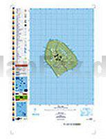
 | PI15 Atiu (Cookinseln) Topographische Landkarte 1:25.000 - Land Information New Zealand |
 | 365.23 Amtliche topographische Karte 1:25.000 Polen |
| 275.12 Amtliche topographische Karte 1:25.000 Polen |
 | The Way of St Benedict Wanderführer (englisch) - Frignani S. - TERRE DI MEZZO |
 | Münchner Skitourenberge 100 traumhafte Skitourenziele. Mit GPS-Tracks - von Markus Stadler - Bergverlag Rother |
| 212.12 Amtliche topographische Karte 1:25.000 Polen |
| L7724 Ulm Topographische Landkarte 1:50.000 - Landesvermessungsamt Baden-Württemberg |
 | 01/7-8 ESSEN NGI 1:25.000 Topographische Landkarte Belgien |
 | Paris - La Défense 1:12.000 / 1:15.000 Stadtplan Borch laminiert |
 | Patmos - Arki - Lipsi 1:45.000 Landkarte Griechische Inseln - Road Editions Pocket - Griechenland |
 | Brasilien 1:4.2 Mio. Landkarte (Blatt 3401) AdventureMap National Geographic Brasil |
| 082 S Engerdal SÃR 1:50.000 - Amtliche Topographische Landkarte Norwegen - Startens Kartverk |
 | 16/3-4 LILLE - KASTERLEE NGI 1:25.000 Topographische Landkarte Belgien |
 | Bakony - Balaton - Touristischer Atlas 1:80.000 (A4) Bakony - Balaton Turista Atlasz Mapland Ungarn |
| 275.11 Amtliche topographische Karte 1:25.000 Polen |
| 125.31 Amtliche topographische Karte 1:25.000 Polen |
| 232.32 Dabrowno Amtliche topographische Karte 1:25.000 Polen |
 | DuMont direkt Reiseführer Tokyo Mit groÃem Cityplan - von Rufus Arndt - DuMont Reiseverlag |
 | Walisisch - Wort für Wort Kauderwelsch-Sprachführer (Band 153) Reise-Know-How Verlag |
 | Säntis - Churfirsten, Von Appenzell zum Walensee Alpinführer Schweizer Alpen Schweizer Alpen-Club |