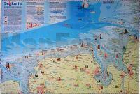
| << Niedersachsen: Ostfriesland und Ostfriesische Inseln << Deutschland: Wandkarten und Poster << Kartenwerk |
  | |
Zuletzt angesehene Artikel:
![]() | Sehkarte Südliche Nordsee - Ostfriesland - Jadebusen - Elbe (PLANO 50 x 70 cm) Ausflugsziele - Leuchttürme - Nationalpark - Verlag Kartenwerk |
![]() | 0023-2 SERRA DO XISTRAL Topographische Landkarte 1:25.000 Spanien (Grundlage MTN25) Instituto Geográfico Nacional - CNIG Spanien - ProjektNord |
![]() | 0841-2 PATERNA DEL MADERA Topographische Landkarte 1:25.000 Spanien (Grundlage MTN25) Instituto Geográfico Nacional - CNIG Spanien - ProjektNord |
![]() | Plan-Mappe Nr. 5: Rhein-Kreis-Neuss und Mönchengladbach Stadtplan von Stadt Mönchengladbach, Dormagen, Grevenbroich, Jüchen, Kaarst, Korschenbroich, Meerbusch, Neuss, Rommerskirchen und Kreiskarte Blees-Verlag |
![]() | 0126-3 VALLE DE FINOLLEDO Topographische Landkarte 1:25.000 Spanien (Grundlage MTN25) Instituto Geográfico Nacional - CNIG Spanien - ProjektNord |
![]() | 0662-3 LA ALMARCHA Topographische Landkarte 1:25.000 Spanien (Grundlage MTN25) Instituto Geográfico Nacional - CNIG Spanien - ProjektNord |
![]() | Aragón - Touristischer Straßenatlas 1:150.000 GPS Aragón - Atlas turÃstico y de carreteras Prames - Spanien |
![]() | 0091-3 QUINTO REAL Topographische Landkarte 1:25.000 Spanien (Grundlage MTN25) Instituto Geográfico Nacional - CNIG Spanien - ProjektNord |
![]() | 0578-4 PEDRO BERNARDO Topographische Landkarte 1:25.000 Spanien (Grundlage MTN25) Instituto Geográfico Nacional - CNIG Spanien - ProjektNord |
![]() | 0641-3 BORRIANA/BURRIANA Topographische Landkarte 1:25.000 Spanien (Grundlage MTN25) Instituto Geográfico Nacional - CNIG Spanien - ProjektNord |
![]() | 0626 CALERA Y CHOZAS Topographische Landkarte 1:50.000 Spanien (Grundlage MTN50) Instituto Geográfico Nacional - CNIG Spanien - ProjektNord |
![]() | 0999-3 EL ROMPIDO Topographische Landkarte 1:25.000 Spanien (Grundlage MTN25) Instituto Geográfico Nacional - CNIG Spanien - ProjektNord |
![]() | 1467 Stolpmünde Topographische Karte 1:25.000 Messtischblatt des Deutschen Reiches - Preußische Landesaufnahme / Reichsamt für Landesaufnahme - Faksimile ProjektNord |
![]() | 1006-1 CASARICHE Topographische Landkarte 1:25.000 Spanien (Grundlage MTN25) Instituto Geográfico Nacional - CNIG Spanien - ProjektNord |
![]() | 0185-2 PONTEVEDRA Topographische Landkarte 1:25.000 Spanien (Grundlage MTN25) Instituto Geográfico Nacional - CNIG Spanien - ProjektNord |
![]() | 1020-2 LA GIRONDA Topographische Landkarte 1:25.000 Spanien (Grundlage MTN25) Instituto Geográfico Nacional - CNIG Spanien - ProjektNord |
![]() | 0991-1 FRAILES Topographische Landkarte 1:25.000 Spanien (Grundlage MTN25) Instituto Geográfico Nacional - CNIG Spanien - ProjektNord |


