| << Deutschland: Topographische Karten 1:25.000 im Regelblattschnitt nach Blattnummern (3000-3999) << Berlin und Brandenburg: Topographische Karte 1:25.000 im Regelblattschnitt - Landesvermessung und Geobasisinformation Brandenburg / ProjektNord << Schnäppchen - Restposten - Mängelexemplare |
  | |
|
||
Zuletzt angesehene Artikel:
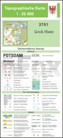
![]() | 3751 Groß Rietz *** SCHNÄPPCHEN *** Topographische Karte 1:25.000 Landesvermessungsamt Brandenburg (gefaltet) |
![]() | Karpaten touristische Landkarte 1:300.000 (englisch) (Ukrainische Karpaten) Carpathians Kartografija - ukrmap Ukraine |
![]() | Trekking in the Moroccan Atlas Reiseführer englisch Trailblazer Moroccan Atlas: The Trekking Guide |
![]() | 5833 Burgkunstadt Topographische Landkarte Bayern 1:25.000 - Normalausgabe - ProjektNord (geplottete Ausgabe) - Grundlage amtliche Topographische Karte Bayern DTK25 |
![]() | Baedeker Reiseführer Dresden MAIRDUMONT |
![]() | 7035 Schamhaupten Topographische Landkarte Bayern 1:25.000 - Normalausgabe - ProjektNord (geplottete Ausgabe) - Grundlage amtliche Topographische Karte Bayern DTK25 |
![]() | CityTrip Thessaloniki Reiseführer mit Stadtplan und kostenloser Web-App - von Daniel Krasa - Reise Know-How |
![]() | 4417 Büren (geplottete Ausgabe) Amtliche topographische Karte 1:25.000 Landesvermessungsamt Nordrhein-Westfalen |
![]() | 7730 Großaitingen Topographische Landkarte Bayern 1:25.000 - Normalausgabe - ProjektNord (geplottete Ausgabe) - Grundlage amtliche Topographische Karte Bayern DTK25 |
![]() | Tschechien - Straßenkarte 1:500.000 Cesko SHOCart |
![]() | Bratislava (Pressburg) + Umgebung 1:12.000 Stadtplan - Slowakei (A5) Bratislava a okolie (A5) SHOCart |
![]() | 19 Böhmisches Paradies Wanderkarte Tschechien 1:50.000 - KCT - Papierausgabe 19 Cesky Raj |
![]() | 7033 Titting Topographische Landkarte Bayern 1:25.000 - Normalausgabe - ProjektNord (geplottete Ausgabe) - Grundlage amtliche Topographische Karte Bayern DTK25 |
![]() | 2513-I - mit Wanderwegen und Fahrradrouten Topographische Fahrradkarte und Wanderkarte Dänemark 1:50.000 - Kort & Matrikelstyrelsen ProjektNord 2513-I - Topografisk Cykel- og Vandrekort Danmark |
![]() | Astrachaner Oblast Straßenatlas 1:200.000 Астраханская область - Атлас автодорог FGUP - Severo-Kavkazskoe aerogeodezičkoe predprijatie |
![]() | Ganz bei mir Leidenschaft Achttausender. Mit Karin Steinbach - von Gerlinde Kaltenbrunner, Karin Steinbach - Malik National Geographic |
![]() | S5414 Lämsänkylä Topographische Karte 1:25.000 EUREF (Peruskartta) Maanmittauslaitos / Lantmäteriverket Finnland - ProjektNord |
![]() | Mallorca - Wanderungen in die Erdgeschichte (30) von Monika Huch und Franz Tessensohn - Verlag Dr. Friedrich Pfeil |
![]() | 106M - Fort McPherson Topographische Landkarte 1:250.000 - Canada - Northwest Territories |


