Willkommen bei MapFox
Wurde Ihre Bestellung bestätigt? Wenn nicht - gab es evtl. ein SERVER-Problem! Bitte kontaktieren Sie uns! +++ Buchhändler-Anfragen erwünscht +++
Warenkorb
Artikel: 0 - € 0.00
Zur Kasse
Impressum Kontakt Versandkosten AGB
NORWAY, NATURALLY 60 unique outdoor experiences and places to stay - Hardanger, Sogn, Jotunheimen, Sunnmøre, Romsdalen, Helgeland, Lofoten, Svalbard (englisch) Fri Flyt AS
<< Norwegen: Wanderführer - Radwanderführer - Reiseführer - Kletterführer
 
Cover

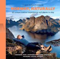
Norway, naturally takes you on a journey to mountains, islands and places to stay around the country.

With its beautiful pictures and concise descriptions, this is the guide to an unforgettable holiday in Norway. Hike over the Romsdal Ridge, mount the great summits in Jotunheimen, and paddle in the Sogn Fjord. Visit scenic islands, experience the midnight sun on a blue glacier, take part in the famous Lofoten cod fishery, and ski & sail with Hurtigruten. All of these are unique trips in their own right. And so are the places to stay; whether you spend the night in mountain cabins, old lighthouses, traditional farm houses or a converted oil tank. You can even stay on board a ship in the ice on Svalbard and get a sense of what it was like to be a Norwegian polar pioneer.

Trygve Sunde Kolderup is the author of the book. He is the manager of Hvitserk, a company that organizes expeditions and adventure tours all over the world. Before this he was the editor of the Norwegian outdoor magazine UTE. Most of the pictures in the book are taken by professional outdoor photographer Matti Bernitz.

"Don’t be surprised if you feel the urge to change your holiday plans after reading Norway, naturally!" - Iver Gjelstenli, outdoor journalist

188 Seiten, Hardcover

Kartenbeispiel

NORWAY, NATURALLY 60 unique outdoor experiences and places to stay - Hardanger, Sogn, Jotunheimen, Sunnmøre, Romsdalen, Helgeland, Lofoten, Svalbard (englisch) Fri Flyt AS
EAN / ISBN: 9788293090168
Preis: EUR 40.00

Bestellartikel: versandfertig in ca. 3-7 Tagen. Dieser Artikel wird speziell für Sie bestellt. Keine Rücknahme!
Produkt EUR Anzahl Bestellen
NORWAY, NATURALLY 60 unique outdoor experiences and places to stay - Hardanger, Sogn, Jotunheimen, Sunnmøre, Romsdalen, Helgeland, Lofoten, Svalbard (englisch) Fri Flyt AS 40.00
Versandkostenfrei in Deutschland

incl. MwSt.

Stichworte, die bei der Suche nützlich sein könnten:
Lofoten - Romsdalen - Norwegen Reiseführer - Sunnmøre - Helgeland - Jotunheimen - Svalbard - Hardanger - Sptzbergen - Sogn - Norwegen Wanderführer - Norwegen Radwanderführer - Norwegen Reiseführer - Norwegische Fernradwege - Norwegen Fernradwege - Norwegen Kletterführer

Zuletzt angesehene Artikel:

CoverNORWAY, NATURALLY 60 unique outdoor experiences and places to stay - Hardanger, Sogn, Jotunheimen, Sunnmøre, Romsdalen, Helgeland, Lofoten, Svalbard (englisch) Fri Flyt AS

Cover2448 Strasburg (Uckermark) Amtliche Topographische Karte 1:25.000 Landesvermessungsamt Mecklenburg-Vorpommern

Cover01-424 Topographische Karte 1:25.000 der Tschechischen Republik
Zakladní mapa Ceská republika Cesky urad zememericky a katastralni - ProjektNord

Cover50 Wanderrouten im Lake District - zwischen 2 und 10 Meilen Wanderführer - AA Automobile Association / OS Ordnance Survey - Großbritannien
50 walks in the Lake District - walking guide

Cover0423 FERMOSELLE Topographische Landkarte 1:50.000 Spanien (Grundlage MTN50) Instituto Geográfico Nacional - CNIG Spanien - ProjektNord

CoverBörzsöny Atlas 1:40.000 Wanderatlas Ungarn (ungarisch)
Börszöny és az ipoly völgye Cartographia Ungarn

Cover22 Mittelmosel - Trier bis Zell 1:35.000 Outdoorkarte - Wanderkarte Traben-Trabach, Bernkastel-Kues - Kümmerly & Frey

CoverMit dem Wohnmobil nach Thüringen (Band 9) Die Anleitung für einen Erlebnisurlaub. Tipps, Tricks, Touren, Tolle Plätze. Alle Plätze mit präzisen GPS-Daten - von Reinhard Schulz und Waltraud Roth-Schulz - WOMO-Verlag

Cover232 VALLON ST.-IMIER 1:50.000 - La Chaux-de-Fonds - Chasseral - Bielersee - Topographische Landeskarte der Schweiz - swisstopo

Noch kein Cover vorhandenN-34-51/52 Braniewo (Braunsberg) Plot aus der Kartengrundlage der amtliche topographische Karte Polen 1:100.000 ProjektNord

CoverThimister - Clermont 1:15.000 Touristische Wanderkarte Belgien NGI Belgien

CoverF04 Le Hohneck 1:35.000 - Frankreich Outdoorkarte Landkarte Wandern, Rad, Nordic Walking - Kümmerly & Frey

Cover206 Camaiore e Massarosa 1:15.000 - topographische Wanderkarte - Italien - 4land
Carta topografica escursionistica della zona di Camaiore e Massarosa, nelle Alpi Apuane

CoverKönigsteingebirge (Piatra Craiului Mountains) 1:30.000 *** SCHNÄPPCHEN *** Transylvanische Alpen - Zentral-Rumänien
Piatra Craiului 1:30.000 BelAlpin TOUR SRL

Cover2349 Ferdinandshof Amtliche Topographische Karte 1:25.000 Landesvermessungsamt Mecklenburg-Vorpommern

CoverWeimar - Der Stadtführer Ein unterhaltsamer Führer durch die Klassik- und Bauhausstadt - von Wolfgang Knape Schmidt-Buch-Verlag

CoverBaie et Vallée de la Somme (Blatt 37) Fahrradkarte und Wanderkarte Frankreich 1:50.000 SPORTOENA

CoverM5414 Parikkala Topographische Karte 1:25.000 EUREF (Peruskartta) Maanmittauslaitos / Lantmäteriverket Finnland - ProjektNord

Cover1741 Trinwillershagen Amtliche Topographische Karte 1:25.000 Landesvermessungsamt Mecklenburg-Vorpommern

CoverNortorf - Wildes Moor Topographische Wanderkarte mit Wanderwegen und Radwegen 1:25.000 Schleswig-Holstein - ProjektNord