Willkommen bei MapFox
Wurde Ihre Bestellung bestätigt? Wenn nicht - gab es evtl. ein SERVER-Problem! Bitte kontaktieren Sie uns! +++ Buchhändler-Anfragen erwünscht +++
Warenkorb
Artikel: 0 - € 0.00
Zur Kasse
Impressum Kontakt Versandkosten AGB
Sunnmøre Alps - Outdoor-Reiseführer (englisch) - von Stig Helset Fri Flyt AS
<< Norwegen: Wanderführer - Radwanderführer - Reiseführer - Kletterführer
 
Cover

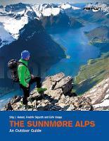
The Sunnmøre Alps are in Western Norway. This is a unique area with majestic peaks and alpine mountain formations rising straight from the sea to a height of 1.500-1.700 meters. This book gives you all the information you need to enjoy skiing, hiking, climbing, mountain biking, kayaking, surfing, kite boarding, windsurfing, paragliding, diving and more in Sunnmøre, Norway. What is so unique about this part of Norway is the huge variety of outdoor experiences you can find within such short distances - within a radius of just 30 kilometers. They show you «the best of the best».

Each activity is presented in a chapter of its own with five to fifteen trips per activity. They present different levels of difficulty within each activity, from the very easy to the more demanding. You will also find a separate chapter on travel and accommodation in Sunnmøre.

Dream yourself away as you leaf through the book on a rainy day, and then when the sun shines, make your dreams come true!

Features:
No of Pages: 232
Page Size: 175 x 225 mm
Illustrations: Color photos, Maps

Kartenbeispiel

Sunnmøre Alps - Outdoor-Reiseführer (englisch) - von Stig Helset Fri Flyt AS
EAN / ISBN: 9788293090069
Preis: EUR 42.00

Bestellartikel: versandfertig in ca. 3-7 Tagen. Dieser Artikel wird speziell für Sie bestellt. Keine Rücknahme!
Produkt EUR Anzahl Bestellen
Sunnmøre Alps - Outdoor-Reiseführer (englisch) - von Stig Helset Fri Flyt AS 42.00
Versandkostenfrei in Deutschland

incl. MwSt.

Stichworte, die bei der Suche nützlich sein könnten:
Sunnmørsalpane - Sunnmörsalpane - Norwegen Wanderführer - Norwegen Radwanderführer - Norwegen Reiseführer - Norwegische Fernradwege - Norwegen Fernradwege - Norwegen Kletterführer

Zuletzt angesehene Artikel:

CoverSunnmøre Alps - Outdoor-Reiseführer (englisch) - von Stig Helset Fri Flyt AS

CoverPC-Lern-Tastatur / Internet im Überblick Schreibtischunterlage 64 x 44 cm - Stiefel EUROCART

Noch kein Cover vorhandenL-33-45-B-c Amtliche Topographische Karte Ungarn 1:25.000

CoverBaedeker Reiseführer Böhmen, Prag mit praktischer Karte EASY ZIP - von Jochen Müssig MAIRDUMONT

Noch kein Cover vorhanden7512 Neuried Topographische Landkarte 1:25.000 - Landesvermessungsamt Baden-Württemberg

CoverMessier-Guide Der ultimative Führer zu 110 Sternhaufen, Nebeln und Galaxien - von Ronald Stoyan - Oculum-Verlag

Cover4528 Worbis Topographische Karte Thüringen 1:25.000 Landesvermessungsamt Thüringen

Cover1726 Flintbek Topographische Landkarte 1:25.000 Landesvermessungsamt Schleswig-Holstein

Noch kein Cover vorhandenBC35 Topographische Landkarte Neuseeland 1:50.000 Land Information New Zealand

CoverAT24 Cape Reinga Topographische Landkarte Neuseeland 1:50.000 Land Information New Zealand

Noch kein Cover vorhanden2545OT ST-CHINIAN - L`ETANG DE MONTADY Topographische Wanderkarte Frankreich 1:25.000 TOP 25 IGN

Noch kein Cover vorhanden1314 O GAVRAY GPS Amtliche Topographische Wanderkarte Frankreich 1:25.000 - série bleue (IGN)

CoverL1740 Ribnitz-Damgarten Amtliche Topographische Karte 1:50.000 Landesvermessungsamt Mecklenburg-Vorpommern

Noch kein Cover vorhanden8223 Ravensburg Topographische Landkarte 1:25.000 - Landesvermessungsamt Baden-Württemberg

Cover6819 Eppingen Topographische Landkarte 1:25.000 - Landesvermessungsamt Baden-Württemberg

Noch kein Cover vorhandenBG42 Topographische Landkarte Neuseeland 1:50.000 Land Information New Zealand

Noch kein Cover vorhandenM-34-134-D-d Amtliche Topographische Karte Ungarn 1:25.000

CoverGriechenland: Skitouren mit Meerblick von Christian Mayer - Anavasi Editions Griechenland

Noch kein Cover vorhanden341.34 Stare Czarnowo Amtliche topographische Karte 1:25.000 Polen

Noch kein Cover vorhanden3850-NW Topographische Karte 1:10.000 - Landesvermessungsamt Brandenburg