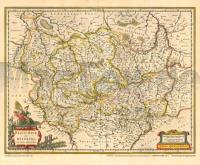
| << Deutschland: Historische Karten und Stadtpläne (im Bereich der heutigen Bundesrepublik) << Rockstuhl |
  | |
Zuletzt angesehene Artikel:
![]() | Historische Karte: Braunschweig und Magdeburg 1636 (Plano) - Mit dem Harz, Anhalt, Eichsfeld, Halberstadt, Halle, Hildesheim, Hohenstein, Mansfeld und Stolberg - Planokarte - gerollt von Janssonius, Joh. - Verlag Rockstuhl |
![]() | 575 Alcoutim Topographische Landkarte Wanderkarte und Fahrradkarte Portugal 1:25.000 575 Mapa topográfico - Mapa de caminhadas - Portugal 1:25.000 ProjektNord |
![]() | 6023 Lohr am Main Topographische Landkarte Bayern 1:25.000 - Normalausgabe - ProjektNord (geplottete Ausgabe) - Grundlage amtliche Topographische Karte Bayern DTK25 |
![]() | 6128 Ebrach Topographische Landkarte Bayern 1:25.000 - Normalausgabe - ProjektNord (geplottete Ausgabe) - Grundlage amtliche Topographische Karte Bayern DTK25 |
![]() | 5922 Frammersbach Topographische Landkarte Bayern 1:25.000 - Normalausgabe - ProjektNord (geplottete Ausgabe) - Grundlage amtliche Topographische Karte Bayern DTK25 |
![]() | 6226 Kitzingen Topographische Landkarte Bayern 1:25.000 - Normalausgabe - ProjektNord (geplottete Ausgabe) - Grundlage amtliche Topographische Karte Bayern DTK25 |
![]() | 6236 Eschenbach Topographische Landkarte Bayern 1:25.000 - Normalausgabe - ProjektNord (geplottete Ausgabe) - Grundlage amtliche Topographische Karte Bayern DTK25 |
![]() | 6341 Frankenreuth Topographische Landkarte Bayern 1:25.000 - Normalausgabe - ProjektNord (geplottete Ausgabe) - Grundlage amtliche Topographische Karte Bayern DTK25 |
![]() | 6141 Treppenstein Topographische Landkarte Bayern 1:25.000 - Normalausgabe - ProjektNord (geplottete Ausgabe) - Grundlage amtliche Topographische Karte Bayern DTK25 |
![]() | 3024 07 Pernoo Topographische Karte 1:20.000 (Maastokartta / Peruskartta / Grundkarta) Maanmittauslaitos / Lantmäteriverket Finnland - ProjektNord |
![]() | 6227 Iphofen Topographische Landkarte Bayern 1:25.000 - Normalausgabe - ProjektNord (geplottete Ausgabe) - Grundlage amtliche Topographische Karte Bayern DTK25 |
![]() | 6020 Aschaffenburg Topographische Landkarte Bayern 1:25.000 - Normalausgabe - ProjektNord (geplottete Ausgabe) - Grundlage amtliche Topographische Karte Bayern DTK25 |
![]() | 5733 Kronach Topographische Landkarte Bayern 1:25.000 - Normalausgabe - ProjektNord (geplottete Ausgabe) - Grundlage amtliche Topographische Karte Bayern DTK25 |
![]() | 6140 Tirschenreuth Topographische Landkarte Bayern 1:25.000 - Normalausgabe - ProjektNord (geplottete Ausgabe) - Grundlage amtliche Topographische Karte Bayern DTK25 |
![]() | B11 Schwarzenbach a.Wald mit Wallenfels, Bad Steben, Geroldsgrün, Nordhalben, Marktrodach, Steinwiesen ATK25 Topographische Karte 1:25.000 (Atkis) Bayern Landesvermessungsamt Bayern - Wanderkarte |
![]() | M05 Neu-Ulm - Ulm, Senden, Nersingen, Pfaffenhofen a.d.Roth, Elchingen, Leipheim, Bibertal, Beimerstetten, Langenau, Gerlenhofen, Reutti, Finningen, Holzheim, Bühl, Burlafingen, Weißenhorn, Wallenhausen, Iller ATK25 Topographische Karte 1:25.000 (Atkis) Bayern Landesvermessungsamt Bayern - Wanderkarte |
![]() | Nordeuropa - Straßenkarte 1:2 Mio. Landkarte/Straßenkarte - Jana seta - Lettland Nothern Europe - Latvia, Estonia, Lithuania, Denmark, Iceland, Finland, Norway, Sweden Jana Seta |
![]() | 5732 Sonnefeld Topographische Landkarte Bayern 1:25.000 - Normalausgabe - ProjektNord (geplottete Ausgabe) - Grundlage amtliche Topographische Karte Bayern DTK25 |
![]() | 6135 Creussen Topographische Landkarte Bayern 1:25.000 - Normalausgabe - ProjektNord (geplottete Ausgabe) - Grundlage amtliche Topographische Karte Bayern DTK25 |
![]() | 4 Naturpark Bergisches Land - Mitte: Bergisch Gladbach - Engelskirchen - Lindlar - Lohmar - Nürnbrecht - Overath - Rösrath - Wiehl Wanderkarte im Naturpark Bergisches Land 1:25.000 Naturarena / Naturpark Bergisches Land |


