| << Deutschland: Historische Karten und Stadtpläne (im Bereich der heutigen Bundesrepublik) << Rockstuhl |
||
|
||

Zuletzt angesehene Artikel:
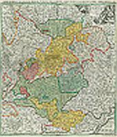
 | Fränkischer Kreis 1707 - Historische Landkarte Nachdruck Planokarte - gerollt von Homann, J. Baptist - Verlag Rockstuhl |
 | Lurøya - Nesøya - Rødøya - Seekarte Norwegische Küste 1:50.000 - (Blatt 62) Den Norske Kyst Sjøkart - Hovedkart (sjø) Statens Kartverk Sjø - Norwegen |
 | Niedere Tauern - Ost *** SCHNÄPPCHEN *** - Muracher Bergen und Turracher Höhe. 50 Touren - von Günter Auferbauer und Luise Auferbauer - Bergverlag Rother |
 | 613 Viðareiði - Färöer - Topographische Karte 1:20.000 613 Færøer - Topografisk kort 1:20.000 - Miliøministeriet - Kort & Matrikelstyrelsen / ProjektNord |
 | Canyonlands National Park: Needles District Trail 1:70.000 (Blatt 311) GPS / Utah Landkarte Trails Illustrated Map wasserfest National Geographic - USA |
 | Notodden - Kongsberg - Skrimfjella - Bø - Lifjell Topographische Wanderkarte Topo 3000 - 1:50.000 (Blatt 3017) - Nordeca - Norwegen |
 | 50W TILBURG (West) Topographische Karte der Niederlande 1:50.000 Topografische Dienst (Plotausgabe) |
| Schemmensee Topographische Karte 1:25.000 Messtischblatt des Deutschen Reiches - Preußische Landesaufnahme / Reichsamt für Landesaufnahme - Faksimile ProjektNord |
 | 0047-3 BAAMONDE Topographische Landkarte 1:25.000 Spanien (Grundlage MTN25) Instituto Geográfico Nacional - CNIG Spanien - ProjektNord |
| RadReiseFührer Fünf-Flüsse-Radweg 6930 Radvergnügen entlang von Naab, Vils, Pegnitz, Altmühl und Donau mit Extra-Tourenkarte, Reiseführer und exakter Streckenbeschreibung - KOMPASS-Karten |
 | Parc naturel régional de Morvan ... à pied - promenades & randonnées - Réf. PN22 Topographischer Wanderführer - FFRP (Fédération française de randonnée pédestre) Frankreich |
 | Delta Nord (Blatt 9) Fahrradkarte und Wanderkarte Belgien 1:50.000 De groene vogelrijke Delta Noord SPORTOENA |
 | 0473-2 TORREDEMBARRA Topographische Landkarte 1:25.000 Spanien (Grundlage MTN25) Instituto Geográfico Nacional - CNIG Spanien - ProjektNord |
 | 3327 (NM 33-10-27) Ostermiething Topographische Wanderkarte 1:50.000 mit Wegmarkierungen - Österreich - Kartographie BEV - ProjektNord |
 | B10 Kronach mit Teuschnitz, Stockheim, Wilhelmsthal, Pressig, Marktrodach, Mitwitz ATK25 Topographische Karte 1:25.000 (Atkis) Bayern Landesvermessungsamt Bayern - Wanderkarte |
 | 312 Kleine Kykladen 1:25.000 Landkarte Griechische Inseln -Terrain Cartography - Griechenland (wasserfest und reissfest) Terrain maps |
 | Elbe/Havel Magdeburg 1:75.000 - ADFC-Regionalkarte reiß- und wetterfest - GPS-Tracks Download Mit Elberadweg von der Havel bis zur Saale - Bielefelder Verlag |
 | 2113-IV-SV Topographische Karte Dänemark 1:25.000 Topografisk kort Danmark (DTK/Kort25) 2113-IV-SV ProjektNord - Kort & Matrikelstyrelsen / Geodætisk Institut |
 | Pskower Oblast 1:100.000 Topografischer Regionalatlas - Russland Atlas Pskovskaja oblastj - FGUP Novgorodskoe Aerogeodezicheskoe Predprijatie - Welikij Nowgorod |
 | NM 33-12-20 (5320) Wien Österreichische Karte 1:50.000 mit Wegmarkierungen (topographische Wanderkarte - UTM) - BEV - Österreich |