| << Deutschland: Historische Karten und Stadtpläne (im Bereich der heutigen Bundesrepublik) << Rockstuhl |
||
|
||
Zuletzt angesehene Artikel:
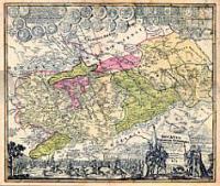
 | Burgen-, Klosterkarte Thüringen u. Sachsen 1732 - Historische Landkarte Nachdruck Planokarte - gerollt von Homann, J. Baptist - Verlag Rockstuhl |
 | 0876-3 NUESTRA SEÃORA DEL VALLE Topographische Landkarte 1:25.000 Spanien (Grundlage MTN25) Instituto Geográfico Nacional - CNIG Spanien - ProjektNord |
 | 3024 07 Pernoo Topographische Karte 1:20.000 (Maastokartta / Peruskartta / Grundkarta) Maanmittauslaitos / Lantmäteriverket Finnland - ProjektNord |
 | 0837-3 HUERTEZUELAS Topographische Landkarte 1:25.000 Spanien (Grundlage MTN25) Instituto Geográfico Nacional - CNIG Spanien - ProjektNord |
 | 3969 Xions Topographische Karte 1:25.000 Messtischblatt des Deutschen Reiches - PreuÃische Landesaufnahme / Reichsamt für Landesaufnahme - Faksimile ProjektNord |
 | 3321 03 PITKÃKANGAS Topographische Karte 1:20.000 (Maastokartta / Peruskartta / Grundkarta) Maanmittauslaitos / Lantmäteriverket Finnland - ProjektNord |
 | Route 66 - 1:1. Mio./ 1:1.1 Mio. *** SCHNÃPPCHEN *** Touristische Landkarte - ITMB International Travel Maps (engl.) |
 | W225 Baden-Baden - Unteres Murgtal - Forbach 1:25.000 Wanderkarte - Karte des Schwarzwaldvereins - Landesamt für Geoinformation und Landentwicklung Baden-Württemberg (LGL) |
 | 0910 CARAVACA DE LA CRUZ Topographische Landkarte 1:50.000 Spanien (Grundlage MTN50) Instituto Geográfico Nacional - CNIG Spanien - ProjektNord |
| 20I SV BJÃRNA 1:50.000 *** SCHNÃPPCHEN *** Topographische Wanderkarte Schweden (Terrängkarta/Gröna Kartan) - Kartförlaget - Lantmäteriet Landkarte Schweden |
 | 275 - Topographische Landkarte Portugal 1:25.000 Carta Militar de Portugal - Série M888 Instituto Geográfico do Exército (IGeoE) - Portugal |
 | 1077-IV Tarifa Amtliche topographische Landkarte 1:25.000 Spanien (M.T.N.) 1077-IV Mapa Topográfico Nacional de Espana (MTN25) Instituto Geográfico Nacional - CNIG Spanien |
 | 704-4 TORREORGAZ Amtliche topographische Landkarte 1:25.000 Spanien (M.T.N.) 704-4 Mapa Topográfico Nacional de Espana (MTN25) Instituto Geográfico Nacional - CNIG Spanien |
 | 424-3 CARBELLINO Amtliche topographische Landkarte 1:25.000 Spanien (M.T.N.) 424-3 Mapa Topográfico Nacional de Espana (MTN25) Instituto Geográfico Nacional - CNIG Spanien |
 | 0456-2 CARBONERO EL MAYOR Topographische Landkarte 1:25.000 Spanien (Grundlage MTN25) Instituto Geográfico Nacional - CNIG Spanien - ProjektNord |
 | 431-2 BARBOLLA Amtliche topographische Landkarte 1:25.000 Spanien (M.T.N.) 431-2 Mapa Topográfico Nacional de Espana (MTN25) Instituto Geográfico Nacional - CNIG Spanien |
 | 3522 08 Rahaselkä Topographische Karte 1:20.000 (Maastokartta / Peruskartta / Grundkarta) Maanmittauslaitos / Lantmäteriverket Finnland - ProjektNord |
 | 0796-4 DÃNIA Topographische Landkarte 1:25.000 Spanien (Grundlage MTN25) Instituto Geográfico Nacional - CNIG Spanien - ProjektNord |
 | 168 - Topographische Landkarte Portugal 1:25.000 Carta Militar de Portugal - Série M888 Instituto Geográfico do Exército (IGeoE) - Portugal |
 | 0291 OLIANA Topographische Landkarte 1:50.000 Spanien (Grundlage MTN50) Instituto Geográfico Nacional - CNIG Spanien - ProjektNord |