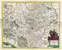
| << Deutschland: Historische Karten und Stadtpläne (im Bereich der heutigen Bundesrepublik) << Rockstuhl |
  | |
Zuletzt angesehene Artikel:
![]() | Thüringen 1690 - Historische Landkarte Nachdruck Planokarte - gerollt von Funcke, David - Verlag Rockstuhl |
![]() | 7131 Monheim Topographische Landkarte Bayern 1:25.000 - Normalausgabe - ProjektNord (geplottete Ausgabe) - Grundlage amtliche Topographische Karte Bayern DTK25 |
![]() | 5427 Helmershausen Topographische Karte Thüringen 1:25.000 Landesvermessungsamt Thüringen |
![]() | 252.1 Amtliche topographische Karte 1:50.000 Polen |
![]() | Kujawien-Pommern (Woiwodschaft) 1:177.000 Straßenkarte / Administrative Karte MAPA SKLADANA WOJEWODZTWA KUJAWSKO-POMORSKIEGO - ADMINISTRACYJNO-SAMOCHODOWA Wydawnictwo Pietka - Polen |
![]() | Pamplona / Iruna Stadtplan Spanien - Planos Callejeros Serie Roja Edition Everest - Spanien |
![]() | 7641 Neumarkt Topographische Landkarte Bayern 1:25.000 - Normalausgabe - ProjektNord (geplottete Ausgabe) - Grundlage amtliche Topographische Karte Bayern DTK25 |
![]() | 34-12 Pohorelice Topographische Karte 1:50.000 der Tschechischen Republik Zakladnà mapa Ceská republika - Cesky urad zememericky a katastralni - ProjektNord |
![]() | Scotland Regional Guide Reiseführer Lonely Planet (engl.) |
![]() | L7328 Hochstädt a. d. Donau (geplottete Ausgabe) Topographische Karte Bayern 1:50.000 Bayerisches Landesvermessungsamt |
![]() | Parque Natural Cañón del RÃo Lobos Wanderkarte 1:25.000 - Editorial Piolet - Spanien |
![]() | Tunesien Straßenkarte 1:850.000 Touristische Landkarte Tunezja seeit mapa Demart - Polen |
![]() | 5577 Tost Topographische Karte 1:25.000 Messtischblatt des Deutschen Reiches - Preußische Landesaufnahme / Reichsamt für Landesaufnahme - Faksimile ProjektNord |
![]() | 242.1 Amtliche topographische Karte 1:50.000 Polen |
![]() | Nowy Tomysl Stadt und Landgemeinde - Stadtplan 1:10.000 - Touristische Landkarte 1:50.000 Nowy Tomyśl miasto i gmina mapa TopMapa Pietruska & Mierkiewicz - Polen |
![]() | Marrakesh Pocket Guide Reiseführer Lonely Planet (engl.) |
![]() | P09 Weilheim in Oberbayern ATK25 Topographische Landkarte 1:25.000 (Atkis) Bayern Landesvermessungsamt Bayern - Wanderkarte |
![]() | Adamello - La Presanella (Nr. 71) 1:50.000 Wanderkarte mit Kurzführer, Radrouten und alpinen Skirouten. Dt. /Ital. 1:50.000 KOMPASS-Karten |
![]() | 4246-SW Topographische Karte 1:10.000 - Landesvermessungsamt Brandenburg |
![]() | MARCO POLO Cityplan Lissabon 1 : 15 000 MairDuMont |


