Willkommen bei MapFox
Wurde Ihre Bestellung bestätigt? Wenn nicht - gab es evtl. ein SERVER-Problem! Bitte kontaktieren Sie uns! +++ Buchhändler-Anfragen erwünscht +++
Warenkorb
Artikel: 0 - € 0.00
Zur Kasse
Impressum Kontakt Versandkosten AGB
Historische WELTKARTE 1652 - Visscher (Plano 62 x 48 cm) - Historische Landkarte Originalinschrift der World Map: Nova Totius Terrarum Orbis Geographica Ac Hydrographica Tabula | Weltkarten Vol. 3 - von Claes Janszoon Visscher - PLANO gerollt - Verlag Rockstuhl
<< Rockstuhl
 
Cover

Farbenprächtiger Nachdruck, Lieferung gerollt, Blattgröße (B x H) 62 x 48 cm,
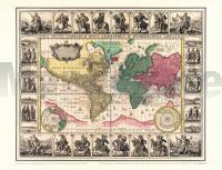
Bedrucktes Blatt (B x H) 53 x 43 cm. Origilalmaßstab ca. 1:90 000 000 - aber die Darstellung um 10 % vergrößert zum Original. Kartographen: Claes Janszoon (1587-1652) und Nicolaes Visscher (1618-1679).

[Lieferung in einer sehr stabilen Pappversandhülse - bis 72 cm lang - 25 g]s

Historische WELTKARTE 1652 - Visscher (Plano 62 x 48 cm) - Historische Landkarte Originalinschrift der World Map: Nova Totius Terrarum Orbis Geographica Ac Hydrographica Tabula | Weltkarten Vol. 3 - von Claes Janszoon Visscher - PLANO gerollt - Verlag Rockstuhl
EAN / ISBN: 9783867776127
Preis: EUR 24.95

sofort versandfertig Dieser Artikel ist im Normalfall sofort lieferbar.
Produkt EUR Anzahl Bestellen
Historische WELTKARTE 1652 - Visscher (Plano 62 x 48 cm) - Historische Landkarte Originalinschrift der World Map: Nova Totius Terrarum Orbis Geographica Ac Hydrographica Tabula | Weltkarten Vol. 3 - von Claes Janszoon Visscher - PLANO gerollt - Verlag Rockstuhl 24.95
Versandkostenfrei in Deutschland ab 30,- Bestellwert

incl. MwSt.

Stichworte, die bei der Suche nützlich sein könnten:
Weltkarte historisch - Verlag Rockstuhl - Historische Karten - Historische Landkarten - Alte Landkarten - Alte Deutschlandkarten

Zuletzt angesehene Artikel:

CoverHistorische WELTKARTE 1652 - Visscher (Plano 62 x 48 cm) - Historische Landkarte Originalinschrift der World Map: Nova Totius Terrarum Orbis Geographica Ac Hydrographica Tabula | Weltkarten Vol. 3 - von Claes Janszoon Visscher - PLANO gerollt - Verlag Rockstuhl

CoverMonte Bianco (Blatt 205) 1:25.000 - Wanderkarte - Courmayeur - Val Veny - Val Ferret - Chamonix-Mont-Blanc - Topographische Wanderkarte - Italien/Frankreich - HIKING MAPS Geo4map - Geo4 Map - Italien

CoverDEUTSCHLAND - ALTGERMANIEN, um 450 - Historische Landkarte Nachdruck Mit den Süd-Donau-Ländern und den Stammesgruppe germanischer Völker Franken - Germanen - Sueven - Gothen - Slaven sowie Römische Provinzen. - von Karl von Spruner - Planokarte - gerollt - Verlag Rockstuhl

Cover0820-2 ONTINYENT Topographische Landkarte 1:25.000 Spanien (Grundlage MTN25) Instituto Geográfico Nacional - CNIG Spanien - ProjektNord

Cover0820 ONTINYENT Topographische Landkarte 1:50.000 Spanien (Grundlage MTN50) Instituto Geográfico Nacional - CNIG Spanien - ProjektNord

Cover454 Setúbal Topographische Landkarte Portugal 1:25.000 Carta Militar de Portugal - Série M888 Instituto Geográfico do Exército (IGeoE) - Portugal