Willkommen bei MapFox
Wurde Ihre Bestellung bestätigt? Wenn nicht - gab es evtl. ein SERVER-Problem! Bitte kontaktieren Sie uns! +++ Buchhändler-Anfragen erwünscht +++
Warenkorb
Artikel: 0 - € 0.00
Zur Kasse
Impressum Kontakt Versandkosten AGB
Historische WELTKARTE 1641 - Henricus Hondius - Historische Landkarte Originalinschrift der World Map: Nova Totivs Terrarvm Orbis Geographica Ac Hydrographica Tabvla | Weltkarten Vol. 2 - von Hondius Henricus - PLANO gerollt - Verlag Rockstuhl
<< Rockstuhl
 
Cover

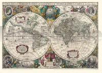
Farbenprächtiger Nachdruck, Lieferung gerollt, Blattgröße (B x H) 67 x 48 cm, Bedrucktes Blatt (B x H) 63 x 43,5 cm. Origilalmaßstab ca. 1:92 000 000 - aber die Darstellung um 10 % vergrößert zum Original. Kartographen: Henricus Hondius (1597-1651) und Johann Janssonius [auch Jan Jansson] (1588-1664).

[Lieferung in einer sehr stabilen Pappversandhülse - bis 72 cm lang - 25 g]

Historische WELTKARTE 1641 - Henricus Hondius - Historische Landkarte Originalinschrift der World Map: Nova Totivs Terrarvm Orbis Geographica Ac Hydrographica Tabvla | Weltkarten Vol. 2 - von Hondius Henricus - PLANO gerollt - Verlag Rockstuhl
EAN / ISBN: 9783867776110
Preis: EUR 24.95

sofort versandfertig Dieser Artikel ist im Normalfall sofort lieferbar.
Produkt EUR Anzahl Bestellen
Historische WELTKARTE 1641 - Henricus Hondius - Historische Landkarte Originalinschrift der World Map: Nova Totivs Terrarvm Orbis Geographica Ac Hydrographica Tabvla | Weltkarten Vol. 2 - von Hondius Henricus - PLANO gerollt - Verlag Rockstuhl 24.95
Versandkostenfrei in Deutschland ab 30,- Bestellwert

incl. MwSt.

Stichworte, die bei der Suche nützlich sein könnten:
Weltkarte historisch - Verlag Rockstuhl - Historische Karten - Historische Landkarten - Alte Landkarten - Alte Deutschlandkarten

Zuletzt angesehene Artikel:

CoverHistorische WELTKARTE 1641 - Henricus Hondius - Historische Landkarte Originalinschrift der World Map: Nova Totivs Terrarvm Orbis Geographica Ac Hydrographica Tabvla | Weltkarten Vol. 2 - von Hondius Henricus - PLANO gerollt - Verlag Rockstuhl

Cover618 Västerås - Terrängkartan 1:50.000 Topographische Wanderkarte Schweden - Lantmäteriet Landkarte Schweden

CoverL5732 Sonneberg (geplottete Ausgabe) Topographische Karte Bayern 1:50.000 Bayerisches Landesvermessungsamt