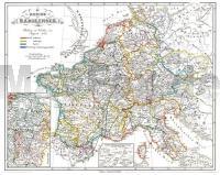
| << Rockstuhl |
  | |
Zuletzt angesehene Artikel:
![]() | Historische Karte: EUROPA - Die REICHE der KAROLINGER - um 850 (Plano) Das Frankenreich. Die Teilung zu Verdun im August 843 - von Hassenstein, Bruno (Kartograf) Spruner, Karl von (Herausgeber) Rockstuhl, Harald (Sonstige) - Verlag Rockstuhl |
![]() | Chile - Argentinien 1:2 Mio. Straßenkarte (Blatt 788) Chili - Argentina Michelin |
![]() | Pickaway County County-Straßenkarte 1:63.000 (Ohio - USA) Pickaway County county map GIS / Cartography & Publishing Services / GM Johnson |
![]() | M-34-35-C/D Chelm Amtliche topographische Landkarte Polen 1:50.000 M-34-35-C/D Chelm - Mapa Topograficzna Polski Glowny Geodeta Kraju |
![]() | M-34-49-C/D Kedzierzyn-Kozle Amtliche topographische Landkarte Polen 1:50.000 M-34-49-C/D Kedzierzyn-Kozle - Mapa Topograficzna Polski Glowny Geodeta Kraju |
![]() | TJ06 Paloona 1:50.000 Topographische Landkarte Tasmanien - Australien - Tasmap (Tasmanien) |
![]() | CD09 Topographische Landkarte Neuseeland 1:50.000 Land Information New Zealand |
![]() | M-33-60-C/D Krapkowice Amtliche topographische Landkarte Polen 1:50.000 M-33-60-C/D Krapkowice - Mapa Topograficzna Polski Glowny Geodeta Kraju |
![]() | 31 Valpelline - Saint Barthélemy - Aosta-Valle Centrale 1:25.000 Topographische Wanderkarte und Straßenkarte 1:25.000 Fraternali Editore - Italien |
![]() | Puula Bootsportkarte 481 - 1:50.000 Puula Veneilykartta 481 - 1:50.000 Yachting chart Finnland |
![]() | Ure - Gimsøystraumen - Svolvær - Seekarte Norwegische Küste 1:50.000 - (Blatt 74) Den Norske Kyst Sjøkart - Hovedkart (sjø) Statens Kartverk Sjø - Norwegen |
![]() | 1073 WIL 1:25.000 - Aadorf - Affeltrangen - Sirnach - Topographische Landeskarte der Schweiz - swisstopo |
![]() | Neumünster Nord Topographische Wanderkarte mit Wanderwegen und Radwegen 1:25.000 Schleswig-Holstein - ProjektNord |
![]() | Værøy - Lofotodden - Seekarte Norwegische Küste 1:50.000 - (Blatt 71) Den Norske Kyst Sjøkart - Hovedkart (sjø) Statens Kartverk Sjø - Norwegen |
![]() | Le Vie del Sale (Blatt 3) - Torriglia e le Valli Scrivia, Trebbia e Aveto - Wanderkarte Italien 1:25.000 dall´Oltrepo Parvese al Mare - Topographische Wanderkarte Studio Cartografico Italiano - Italien |
![]() | 1348 ZERMATT - Breithorn - Gornergrat - Dufourspitze 1:25.000 Topographische Landeskarte der Schweiz - swisstopo |
![]() | M-35-49-C/D Sokal Amtliche topographische Landkarte Polen 1:50.000 M-35-49-C/D Sokal - Mapa Topograficzna Polski Glowny Geodeta Kraju |
![]() | CF04 Topographische Landkarte Neuseeland 1:50.000 Land Information New Zealand |
![]() | M-33-34-C/D Wroclaw - West Amtliche topographische Landkarte Polen 1:50.000 M-33-34-C/D Wroclaw - West - Mapa Topograficzna Polski Glowny Geodeta Kraju |
![]() | PANORAMA - 16 fantastische Radrouten WEST - Radwanderführer PANORAMA - 16 fantastiske cykelruter VEST Legind - Dänemark |


