| << Esterbauer bike line / hikeline / skate line / bett & bike |
  | |
Zuletzt angesehene Artikel:
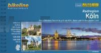
![]() | Köln Radatlas 1:50.000/1:20.000 Die schönsten Touren in und um Köln, Bonn und ins Bergische Land - bikeline Radwanderführer - Esterbauer |
![]() | 0933-1 PLIEGO Topographische Landkarte 1:25.000 Spanien (Grundlage MTN25) Instituto Geográfico Nacional - CNIG Spanien - ProjektNord |
![]() | 2213-I-SV Topographische Karte Dänemark 1:25.000 Topografisk kort Danmark (DTK/Kort25) 2213-I-SV ProjektNord - Kort & Matrikelstyrelsen / Geodætisk Institut |
![]() | 0086-1 ARTZINIEGA Topographische Landkarte 1:25.000 Spanien (Grundlage MTN25) Instituto Geográfico Nacional - CNIG Spanien - ProjektNord |
![]() | G15 Oberviechtach - Schönsee - Treffelstein - Tiefenbach - Winklarn - Teunz - Dieterskirchen Wander- und Radkarte. UTM. GPS - Landesamt für Vermessung und Geoinformation Bayern - ATK25 Topographische Karte 1:25.000 (Atkis) Bayern Landesvermessungsamt Bayern - Wanderkarte - Radwanderkarte |
![]() | 1077-1 FACINAS Topographische Landkarte 1:25.000 Spanien (Grundlage MTN25) Instituto Geográfico Nacional - CNIG Spanien - ProjektNord |
![]() | 0060 BALMASEDA Topographische Landkarte 1:50.000 Spanien (Grundlage MTN50) Instituto Geográfico Nacional - CNIG Spanien - ProjektNord |
![]() | 0084-3 PEDROSA DE VALDEPORRES Topographische Landkarte 1:25.000 Spanien (Grundlage MTN25) Instituto Geográfico Nacional - CNIG Spanien - ProjektNord |
![]() | 0855-2 EL BERCIAL Topographische Landkarte 1:25.000 Spanien (Grundlage MTN25) Instituto Geográfico Nacional - CNIG Spanien - ProjektNord |
![]() | 0665-4 SINARCAS Topographische Landkarte 1:25.000 Spanien (Grundlage MTN25) Instituto Geográfico Nacional - CNIG Spanien - ProjektNord |
![]() | 0203-1 SAN ASENSIO Topographische Landkarte 1:25.000 Spanien (Grundlage MTN25) Instituto Geográfico Nacional - CNIG Spanien - ProjektNord |
![]() | 0698-4 PALMA Topographische Landkarte 1:25.000 Spanien (Grundlage MTN25) Instituto Geográfico Nacional - CNIG Spanien - ProjektNord |
![]() | 0761-1 MADARA Topographische Landkarte 1:25.000 Spanien (Grundlage MTN25) Instituto Geográfico Nacional - CNIG Spanien - ProjektNord |
![]() | 0977-2 CARTAGENA Topographische Landkarte 1:25.000 Spanien (Grundlage MTN25) Instituto Geográfico Nacional - CNIG Spanien - ProjektNord |
![]() | 0087-4 OTXANDIO Topographische Landkarte 1:25.000 Spanien (Grundlage MTN25) Instituto Geográfico Nacional - CNIG Spanien - ProjektNord |
![]() | 0392 SABADELL Topographische Landkarte 1:50.000 Spanien (Grundlage MTN50) Instituto Geográfico Nacional - CNIG Spanien - ProjektNord |
![]() | 0864-4 LOS MOCHUELOS Topographische Landkarte 1:25.000 Spanien (Grundlage MTN25) Instituto Geográfico Nacional - CNIG Spanien - ProjektNord |
![]() | 2215-I-NV Topographische Karte Dänemark 1:25.000 Topografisk kort Danmark (DTK/Kort25) 2215-I-NV ProjektNord - Kort & Matrikelstyrelsen / Geodætisk Institut |
![]() | 2312-III-NV Topographische Karte Dänemark 1:25.000 Topografisk kort Danmark (DTK/Kort25) 2312-III-NV ProjektNord - Kort & Matrikelstyrelsen / Geodætisk Institut |
![]() | 1044-4 FELIX Topographische Landkarte 1:25.000 Spanien (Grundlage MTN25) Instituto Geográfico Nacional - CNIG Spanien - ProjektNord |


