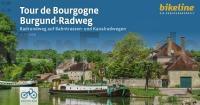
| << Esterbauer bike line / hikeline / skate line / bett & bike |
  | |
Zuletzt angesehene Artikel:
![]() | Tour de Bourgogne - Burgund-Radweg Radrundweg auf Bahntrassen- und Kanalradwegen, 664 km, 75.000, GPS-Tracks, LiveUpdate - von Esterbauer Verlag, Esterbauer (Herausgeber) - bikeline Esterbauer |
![]() | 482 - Topographische Landkarte Portugal 1:25.000 Carta Militar de Portugal - Série M888 Instituto Geográfico do Exército (IGeoE) - Portugal |
![]() | 4454 Bad Muskau Sonderausgabe mit Wanderwegen - Topographische Wanderkarte Brandenburg 1:25.000 ProjektNord |
![]() | Lonely Planet Reiseführer Laos |
![]() | 26 Zagora - Foum Zguid - Tagounite - Nationalpark Iriqui Topographische Straßenkarte 1:250.000 - Marokko ProjektNord |
![]() | 6633 Feucht Topographische Landkarte Bayern 1:25.000 - Normalausgabe - ProjektNord (geplottete Ausgabe) - Grundlage amtliche Topographische Karte Bayern DTK25 |
![]() | A Pilgrim`s Guide to the Camino de Santiago *** SCHNÄPPCHEN *** St. Jean - Roncesvalles - Santiago - The Way of St. James - The ancient pilgrim path also known as Camino Francés - by John Brierley Caminoguides - Findhorn Press |
![]() | Blatt: 41 Schweden-Nord 1:500.000 - Straßenkarte - Calazo Förlag Schweden Vägkarta Norra Sverige |
![]() | ICOON - Ausgabe Croco Globales Bilderwörterbuch ICOON |
![]() | America Central planning map Planungskarte (engl.) Lonely Planet |
![]() | 11 S. Mateus (Pico - Azoren) - Topographische Karte Portugal 1:25.000 Carta Militar de Portugal - Série M889 - 1/25 000 (Acores) - Instituto Geográfico do Exército (IGeoE) - Portugal |
![]() | Senne Topographische Wanderkarte Nordrhein-Westfalen mit Wanderwegen und Radwegen 1:25.000 - ProjektNord |
![]() | 24 Tiznit - Sidi Ifni - Guelmim - Tafraout Topographische Straßenkarte 1:250.000 - Marokko ProjektNord |
![]() | 4218 Paderborn (geplottete Ausgabe) Amtliche topographische Karte 1:25.000 Landesvermessungsamt Nordrhein-Westfalen |
![]() | Baedeker Reiseführer Portugal von Borowski, Birgit u. Bourmer, Achim, Hassenpflug Prof. Dr., Wolfgang, Missler Dr., Eva |
![]() | 2117-II Hanstholm (mit 2117-III) - mit Wanderwegen und Fahrradrouten Topographische Fahrradkarte und Wanderkarte Dänemark 1:50.000 - Kort & Matrikelstyrelsen ProjektNord 2117-II Hanstholm - Topografisk Cykel- og Vandrekort Danmark |
![]() | L2928 Bad Bevensen (geplottete Ausgabe) Topographische Karte 1:50.000 Kartografie Landesvermessungsamt Niedersachsen - ProjektNord |
![]() | Fife Coastal Path - Kincardine to Newburgh (engl.) Wanderkarte Strip map of the route Footprint Maps - Stirling Surveys |
![]() | Makalu Himal von Jan Kielkowski Explo Publishers |
![]() | 8436 Rottach-Egern Süd Topographische Landkarte Bayern 1:25.000 - Normalausgabe - ProjektNord (geplottete Ausgabe) - Grundlage amtliche Topographische Karte Bayern DTK25 |


