Willkommen bei MapFox
Wurde Ihre Bestellung bestätigt? Wenn nicht - gab es evtl. ein SERVER-Problem! Bitte kontaktieren Sie uns! +++ Buchhändler-Anfragen erwünscht +++
Warenkorb
Artikel: 0 - € 0.00
Zur Kasse
Widerruf Impressum Kontakt Versandkosten AGB
Walking on the Amalfi Coast 32 walks on Ischia, Capri, Sorrento, Positano and Amalfi - Wanderführer - Cicerone (englisch)
<< Italien: Wanderführer und Reiseführer
<< Cicerone
 
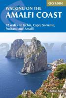
Cover

The steep southern edge of the Sorrento peninsula, on the Gulf of Naples, is famous for its medieval villages perched above plunging cliffs with near-vertical vineyards and lemon orchards. Combined with the rugged landscape of the Monti Lattari further inland, and the idyllic islands of Capri and Ischia, the Amalfi Coast makes a perfect holiday destination for walkers.

Walking on the Amalfi Coast by Gillian Price describes 30 days walks from 3km to 11km in length. Every single walk in this guidebook can be accessed by public transport, as indeed all the research was done. Services are reliable, punctual and very reasonably priced.

The Amalfi Coast, Sorrento peninsula and the island of Capri and Ischia are beautiful walking destinations at any time of year. Spring is warmly recommended for lovers of wild flowers and mild air temperatures. Midsummer can be pretty hot, though sea breezes can usually be counted on. Autumn brings crystal clear skies, russet colours and quieter paths. Winter can be superb with few other visitors and low season prices; however, strong winds and stormy conditions can lower temperatures dramatically.

  • World Heritage Site criss-crossed by ancient mule tracks and pilgrim routes for easy navigation
  • 30 day walks described, from 3km to 11km
  • colour maps and photographs
  • Kartenausschnitt

    Kartenbeispiel

    Walking on the Amalfi Coast 32 walks on Ischia, Capri, Sorrento, Positano and Amalfi - Wanderführer - Cicerone (englisch)
    EAN / ISBN: 9781852848828
    Preis: EUR 27.90

Bestellartikel: versandfertig in ca. 3-7 Tagen. Dieser Artikel wird speziell für Sie bestellt. Keine Rücknahme!
Produkt EUR Anzahl Bestellen
Walking on the Amalfi Coast 32 walks on Ischia, Capri, Sorrento, Positano and Amalfi - Wanderführer - Cicerone (englisch) 27.90
Versandkostenfrei in Deutschland ab 30,- Bestellwert

incl. MwSt.

Stichworte, die bei der Suche nützlich sein könnten:
Capri - Ischia - Amalfi - Amalfi Coast - Sorrento - Positano - Cicerone - Cicerone Radwanderführer - Cicerone Wanderführer - Großbritannien Radwanderführer - Großbritannien Wanderführer - Cicerone Großbritannien - Italien Wanderführer - Italien Reiseführer

Zuletzt angesehene Artikel:

CoverWalking on the Amalfi Coast 32 walks on Ischia, Capri, Sorrento, Positano and Amalfi - Wanderführer - Cicerone (englisch)

CoverTrekking in Greece The Peloponnese and Pindos Way - Wanderführer - Cicerone (englisch)

CoverOL24 The Peak District - White Peak area - Wanderkarte Großbritannien 1:25.000 NEW EXPLORER MAP - Ordnance Survey

CoverC5138 Gera - Topografische Karte 1:100.000 Normalausgabe mit UTM-Gitter (WGS84) - Thüringer Landesvermessungsamt

CoverWeltkugel aufblasbar (ø 30 cm) englisch
Inflatable globe 30 pol. globe Caly Toys

CoverPale di S. Martino - Vette - Cimonega Wanderkarte und Mountainbike-Karte 1:25.000 GPS (Blatt 6)
Carta Escursionistica e Mountainbike Casa Editrice Lagiralpina - Italien

Cover250 Norfolk Coast West - Wanderkarte Großbritannien 1:25.000 EXPLORER MAP - Active Map LAMINIERT - Ordnance Survey

CoverVal Rendena - Carè - Brenta - Làres- Wanderkarte und Mountainbike-Karte 1:25.000 GPS (Blatt 22)
Carta Escursionistica e Mountainbike Casa Editrice Lagiralpina - Italien

Cover05 Basel Solothurner Jura - Wanderkarte Schweiz 1:40.000 wasserfest - Kümmerly & Frey

CoverLake District National Park Outdoor Atlas 1:40.000 (wasserfest) Wandern & Radfahren - HARVEY MAPS
Lake District National Park Outdoor Atlas - Walking & Cycling (wasserfest)

CoverThe Isle of Mull Wanderführer (englisch) Terry Marsh - 208 Seiten
Walking on The Isle of Mull - Over 45 Routes including Offshore Islands - A Cicerone Guide by Terry Marsh Cicerone Großbritannien

CoverBrasilien - Amazonas 1:2.5 Mio. Nelles-Map
Brazil Amazon Nelles-Verlag

CoverL24 Topographische Karte 1:100.000 EUREF-FIN Maanmittauslaitos / Lantmäteriverket Finnland - ProjektNord

CoverBrabant - Wallonien - Samber-Tal (Blatt 13) Fahrradkarte und Wanderkarte Belgien 1:50.000
Waals Brabant en de Samber vallei SPORTOENA

CoverPanamericana mit dem Auto von Alaska bis Feuerland - von Nertinger, Sonja Schier, Klaus - Reise Know-How Verlag Peter Rump

Cover169 Grenze Slowakei - Göding Fahrradkarte Tschechien 1:60.000
Slovácko - Hodonínsko - SHOCart

Cover142 Shepton Mallet & Mendip Hills East - Wanderkarte Großbritannien 1:25.000 EXPLORER MAP - Ordnance Survey

CoverR04 Scheidegg - Weiler-Simmerberg, Lindenberg i.Allgäu, Sigmarszell, Hergensweiler ATK25 Topographische Karte 1:25.000 (Atkis) Bayern Landesvermessungsamt Bayern - Wanderkarte

Cover6220 Wörth Topographische Landkarte Hessen 1:25.000 - ProjektNord

CoverNaturpark Südeifel Blatt 2 (Mitte) Neuerburg - Körperich - Vianden (S2) Topographische Wanderkarte 1:25.000 - Landesamt für Vermessung und Geobasisinformation Rheinland-Pfalz
