Willkommen bei MapFox
Wurde Ihre Bestellung bestätigt? Wenn nicht - gab es evtl. ein SERVER-Problem! Bitte kontaktieren Sie uns! +++ Buchhändler-Anfragen erwünscht +++
Warenkorb
Artikel: 0 - € 0.00
Zur Kasse
Impressum Kontakt Versandkosten AGB
Walking in Austria - Over 100 Walks and Multi-Day Treks - Wanderführer Österreich - Cicerone (englisch)
<< Österreich: Wanderführer und Wintersportführer
<< Cicerone
 
Cover

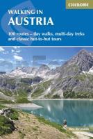
Austria is one of Europe’s most walker-friendly countries. Its 40,000km of well-maintained and waymarked trails through breathtaking scenery pass more than a thousand mountain huts and countless attractive villages, hospitable hotels, inns and restaurants. It also boasts an extensive, integrated public transport system that is particularly useful for walkers.

This comprehensive new guide by Alpine expert Kev Reynolds outlines over 100 of the best walks in ten districts that illustrate the rich diversity of the Eastern Alps - with all the information you need to make the most of an active mountain holiday in Austria.

  • 102 routes described, suitable for a wide range of abilities and ambitions
  • classic - and little-known - hut-to-hut tours
  • information on public transport, accommodation, gear required and safety issues
  • full details of 135 mountain huts
  • German-English glossary
  • covers the Ratikon, Silvretta, Otztal, Stubai, Zillertal and Kitzbuheler Alps, and the Kaisergebirge, Dachsteingebirge, Hohe Tauern and Karawanken
  • Kartenausschnitt

    Kartenbeispiel

    Walking in Austria - Over 100 Walks and Multi-Day Treks - Wanderführer Österreich - Cicerone (englisch)
    EAN / ISBN: 9781852848590
    Preis: EUR 28.90

Bestellartikel: versandfertig in ca. 3-7 Tagen. Dieser Artikel wird speziell für Sie bestellt. Keine Rücknahme!
Produkt EUR Anzahl Bestellen
Walking in Austria - Over 100 Walks and Multi-Day Treks - Wanderführer Österreich - Cicerone (englisch) 28.90
Versandkostenfrei in Deutschland ab 30,- Bestellwert

incl. MwSt.

Stichworte, die bei der Suche nützlich sein könnten:
Austria - Österreich Wanderführer - Österreich - Cicerone - Cicerone Radwanderführer - Cicerone Wanderführer - Großbritannien Radwanderführer - Großbritannien Wanderführer - Cicerone Großbritannien - Österreich - Österreich Wanderführer - Österreich Skiführer - Österreich Wintersportführer

Zuletzt angesehene Artikel:

CoverWalking in Austria - Over 100 Walks and Multi-Day Treks - Wanderführer Österreich - Cicerone (englisch)

Noch kein Cover vorhanden090 S Tynset SØR 1:50.000 - Amtliche Topographische Landkarte Norwegen - Startens Kartverk

Noch kein Cover vorhandenN-34-121-C/D Kleczew Amtliche topographische Landkarte Polen 1:50.000
N-34-121-C/D Kleczew - Mapa Topograficzna Polski Glowny Geodeta Kraju

CoverSüdtirol West: Vinschgau, Meraner Land, Kalterer See, 52 Touren zwischen Stilfser Joch und Sterzing Rother Wanderbuch - Bergverlag Rother

CoverTauferer Ahrntal 1:33.000 (18) FunBike MTB-Gebietsführer Südtirol Bike Arena

Noch kein Cover vorhanden255.32 Amtliche topographische Karte 1:25.000 Polen

CoverKanada Strassenkarte Ost Kanada Strassenkarte West 1:2.5 Mio - Hallwag

CoverLake District Trail & Fell Running in the Lake District Wanderführer Lake District - Cicerone Großbritannien (englisch)

CoverSiebenbürgen (Transilvanien) Straßenkarte Rumänien 1:500.000
Transylvania/Erdély Cartographia

CoverToulouse 1:15.000 - laminierter Stadtplan comfort!map ExpressMap

Noch kein Cover vorhandenCA16 Topographische Landkarte Neuseeland 1:50.000 Land Information New Zealand

CoverThingvallavatn Luftbildkarte GPS *** SCHNÄPPCHEN *** 1:25.000
Þingvallavatn Myndkort / photomap ´Af Stað´ Loftmyndir ehf. - Island

CoverBukarest - Großer Stadtplan 1:26.000 mit Innenstadtplan 1:10.000
Bucharest - Rumänien - Cartographia

CoverNiedere Tauern (Ost) - Murauher Bergen und Turracher Höhe. 55 Touren - von Günter Auferbauer und Luise Auferbauer - Bergverlag Rother

Cover28 Rivierengebied oost - Fahrradkarte 1:66.666 Rivierengebied oost fietskaart
Rivierengebied oost - ANWB fietskaart 28 - ANWB - Niederlande

CoverKönigreich HANNOVER, 1865 - Historische Landkarte Nachdruck Planokarte - gerollt - von H. Kiepert u. C. Ohmann. Revidiert von C. Gräf - Verlag Rockstuhl

CoverPolen plus Europa Autoatlas 1:500.000
Polska plus Europa atlas Demart - Polen

CoverWeltkarte zum Ausmalen - Entdecke die Welt Markiertafel - Freytag-Berndt und ARTARIA

CoverThailand 1:1.2 Mio. Landkarte (Blatt 3006) AdventureMap National Geographic

CoverSehenswürdigkeiten der Küstenlandschaft Danzig - Bildkarte (deutschsprachig) - Terra Nostra - Polen