Willkommen bei MapFox
Wurde Ihre Bestellung bestätigt? Wenn nicht - gab es evtl. ein SERVER-Problem! Bitte kontaktieren Sie uns! +++ Buchhändler-Anfragen erwünscht +++
Warenkorb
Artikel: 0 - € 0.00
Zur Kasse
Impressum Kontakt Versandkosten AGB
Italy`s Sibillini National Park Wanderführer (englisch) Walking and Trekking Guide by Gillian Price
Italy`s Sibillini National Park - Walking and Trekking Guide Cicerone Großbritannien
<< Italien: Wanderführer und Reiseführer
<< Cicerone
 
Cover

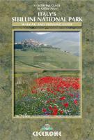
An inspirational guidebook to walking and trekking in Italy`s Sibillini National Park includes the GAS, Grande Anello dei Sibillini, 8-day trek. Easily reached from airports on the Adriatic coast and from Rome, the Monti Sibillini belong to the Appenine chain that straddles the Marche and Umbria, and will become a popular walking destination.

This inspirational guide to walking and trekking in Italy`s Sibillini National Park includes a full description of the GAS, Grande Anello dei Sibillini, 8-day circular trek. Easily reached from the budget airline destinations on the Adriatic coast and from Rome, the Monti Sibillini belong to the Appenine chain that straddles the Marche and Umbria, and are set to become a popular international walking destination. Currently little known to foreign visitors, they offer vast highlands smothered in wildflowers, canyons burrowing deep into mountainsides, accessible ridges with breathtaking views and over 50 peaks, many over 2000m.

? 21 shorter walks and one 8-day trek, suitable for walkers of all abilities
? a long walking season, from early spring to late autumn
? the first original English-language guide to the area
? details of accommodation, refreshments and public transport along all the routes with full-colour mapping and profiles

Kartenausschnitt

Italy`s Sibillini National Park Wanderführer (englisch) Walking and Trekking Guide by Gillian Price
Italy`s Sibillini National Park - Walking and Trekking Guide Cicerone Großbritannien
EAN / ISBN: 9781852845353
Preis: EUR 22.90

Bestellartikel: versandfertig in ca. 3-7 Tagen. Dieser Artikel wird speziell für Sie bestellt. Keine Rücknahme!
Produkt EUR Anzahl Bestellen
Italy`s Sibillini National Park Wanderführer (englisch) Walking and Trekking Guide by Gillian Price
Italy`s Sibillini National Park - Walking and Trekking Guide Cicerone Großbritannien
22.90
Versandkostenfrei in Deutschland ab 30,- Bestellwert

incl. MwSt.

Stichworte, die bei der Suche nützlich sein könnten:
Italien Wanderführer - Nationalpark Sibillini Wanderführer - Sibillini Reiseführer - Monti Sibillini - Monti Sibillini Wanderführer - Sibillini Wanderführer - Sibillini National Park - Italien Wanderführer - Italien Reiseführer - Cicerone - Cicerone Radwanderführer - Cicerone Wanderführer - Großbritannien Radwanderführer - Großbritannien Wanderführer - Cicerone Großbritannien

Zuletzt angesehene Artikel:

CoverItaly`s Sibillini National Park Wanderführer (englisch) Walking and Trekking Guide by Gillian Price
Italy`s Sibillini National Park - Walking and Trekking Guide Cicerone Großbritannien

CoverReiseführer Thüringen Kultur- und Naturschätze im Grünen Herz Deutschlands - von Andreas Bechmann - TRESCHER

CoverMobil Reisen Korsika Mobile Touring Highlights. Reiseführer für individuelle Touren mit Auto, Wohnmobil und Motorrad, GPS-Koordinaten - Werner Rau Verlag

CoverVercelli Provinzialautokarte - Straßenkarte 1:150.000 - Italien
Vercelli - Carta stradale della Provincia - Italia L.A.C. GlobalMap Italien

Cover1267 GEMMI 1:25.000 - Wildstrubel - Engstligenalp - Leukerbad - Topographische Landeskarte der Schweiz - swisstopo

CoverDjursland Topographische Karte Dänemark 1:100.000
Djursland Kort & Matrikelstyrelsen ProjektNord

Cover2926SB Montceau-les-Mines - Ecuisses GPS Amtliche Topographische Wanderkarte Frankreich 1:25.000 - série bleue (IGN)

CoverStorslett - Kåfjord - Guolasjavri 1:50.000 Sonderkarte Wanderkarte - Calazo Förlag Schweden

Cover157 Marsgebirge - Kremsier - Zlin - Fahrradkarte Tschechien 1:70.000
Chriby - Kromerízsko - Zlínsko - cykloturistická mapa KARTOGRAFIE PRAHA

CoverThings to do in Moer & Gone Places A guide to over 100 South Africa´s outdoor secrets - Activities - Accomodation - Amenities - Sights - MapStudio Südafrika

CoverL3122 Saltvik Topographische Karte 1:25.000 EUREF (Peruskartta) Maanmittauslaitos / Lantmäteriverket Finnland - ProjektNord

CoverJelgava (Mitau) Kreiskarte und Stadtplan 1:100.000 / 1:20.000 mit weiteren Stadtplänen
Jelgavas Rajons / Jelgavas Pilseta - Jana Seta - Lettland

CoverWandertouren in Sarek Wanderführer (schwedischsprachig)
Vandringsturer i Sarek Vildmarksbiblioteket Schweden

CoverL6930 Weißenburg i. Bay. (geplottete Ausgabe) Topographische Karte Bayern 1:50.000 Bayerisches Landesvermessungsamt

CoverRund um den Hennesee, Meschede, Bestwig Wanderkarte mit Ausflugszielen, Einkehr- und Freizeittipps, 1:30.000 - von - Freytag-Berndt und ARTARIA Publicpress

CoverEuropäischer Fernwanderweg E5 - Von Konstanz nach Verona (Nr. 5962) Wanderführer mit Extra-Tourenkarte, 32 Etappen, GPX-Daten zum Download - KOMPASS-Karten

CoverOberes Mittelrheintal Bl. 2 - Loreley UNESCO-WELTERBE (OM2) Topografische Wanderkarte 1:25.000 - Landesamt für Vermessung und Geobasisinformation Rheinland-Pfalz

Cover5219 Amöneburg Topographische Landkarte Hessen 1:25.000 - ProjektNord (geplottete Ausgabe)

CoverLiebliches Taubertal 1:50.000 Zwischen Rothenburg ob der Tauber und Wertheim - bikeline Radwanderführer - Esterbauer

CoverHabichtswaldsteig - von Zierenberg zum Edersee (Band 476) OutdoorHandbuch - Der Weg ist das Ziel von Ingrid Retterath - Stein, Conrad, Verlag