Willkommen bei MapFox
Wurde Ihre Bestellung bestätigt? Wenn nicht - gab es evtl. ein SERVER-Problem! Bitte kontaktieren Sie uns! +++ Buchhändler-Anfragen erwünscht +++
Warenkorb
Artikel: 0 - € 0.00
Zur Kasse
Impressum Kontakt Versandkosten AGB
Dales Way Wanderkarte 1:40.000 XT40 - Long Distance Route - HARVEY MAPS
Dales Way - XT40 - Long Distance Route Map
<< Großbritannien: Wanderkarten, Radwanderkarten und MTB-Karten
<< Harvey Maps
 
Cover

A leap forward in technical excellence: Tough, durable and 100% waterproof - this map for walkers is virtually indestructible in normal use.

Compact and light - the map itself weighs just 60gms - a third of the weight of a bulky laminated map. You can fold or refold it time and again, or stuff it in your back pocket and it won`t fall to pieces.

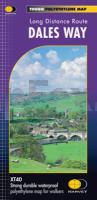
Shows the entire route on one sheet.

130km (81 miles) from Ilkley in Yorkshire through the Dales via Grassington, Buckden and Dent to Bowness on Windermere in the Lake District. Contains all 3 links: from Leeds, Shipley (Bradford) and Harrogate.

Kartenausschnitt

Kartenbeispiel

Dales Way Wanderkarte 1:40.000 XT40 - Long Distance Route - HARVEY MAPS
Dales Way - XT40 - Long Distance Route Map
EAN / ISBN: 9781851374281
Preis: EUR 24.90

Bestellartikel: versandfertig in ca. 3-7 Tagen. Dieser Artikel wird speziell für Sie bestellt. Keine Rücknahme!
Produkt EUR Anzahl Bestellen
Dales Way Wanderkarte 1:40.000 XT40 - Long Distance Route - HARVEY MAPS
Dales Way - XT40 - Long Distance Route Map
24.90
Versandkostenfrei in Deutschland ab 30,- Bestellwert

incl. MwSt.

Stichworte, die bei der Suche nützlich sein könnten:
Yorkshire Dales - Dales Way (Großbritannien) Wanderkarte - Dales Way (Great Britain) Hiking Map - Großbritannien Wanderkarten - Großbritannien Fahrradkarten - Großbritannien Mountainbike-Karten - Harvey maps - Superwalker - Schottland Wanderkarten - Großbritannien Wanderkarten - Harvay - Harway Maps - Britsh Mountain Maps - BMC - Ultramaps - XT40 - XT25 - Great Britain walking maps - UK hiking maps - Scotland hiking maps - Harveymaps - UK Walking maps - Great Britain walking maps

Zuletzt angesehene Artikel:

CoverDales Way Wanderkarte 1:40.000 XT40 - Long Distance Route - HARVEY MAPS
Dales Way - XT40 - Long Distance Route Map

CoverDominican Republic Guide Reiseführer (engl.) Lonely Planet

CoverL243 Geta Topographische Karte 1:50.000 EUREF-FIN (Maastokarttat) Maanmittauslaitos / Lantmäteriverket Finnland - ProjektNord

CoverLandkreis Czarnikau-Schönlanke - Wanderkarte 1:70.000 (Blatt 303)
POWIAT CZARNKOWSKO-TRZCIANECKI Cartomedia - TopMapa / Pietruska & Mierkiewicz Polen

CoverP342 Mickelsörarna Topographische Karte 1:50.000 EUREF-FIN (Maastokarttat) Maanmittauslaitos / Lantmäteriverket Finnland - ProjektNord

Cover71 Beskiden - Javornik-Gebirge Wanderkarte Tschechien 1:50.000
Beskydy, Javorníky - SHOCart

Noch kein Cover vorhanden2182 Alt Christburg Topographische Karte 1:25.000 Messtischblatt des Deutschen Reiches - Preußische Landesaufnahme / Reichsamt für Landesaufnahme - Faksimile ProjektNord

Cover3652 Jacobsdorf Topographische Karte 1:25.000 Landesvermessungsamt Brandenburg (gefaltet)

CoverTaurage - Niederlitauen (West-Litauen) Touristische Landkarte 1:130.000
Pietu Zemaitija - Briedis - Litauen

Cover443 Ben Klibreck & Ben Armine - Wanderkarte Großbritannien 1:25.000 EXPLORER MAP - Ordnance Survey

CoverThe Cretan Way (E4) - Wanderführer - a 28-day walk mit topografischen Kartenausschnitten (englisch, griechisch) - von Luca Gianotti - Anavasi - Griechenland

Cover235 Wisbech & Peterborough North - Wanderkarte Großbritannien 1:25.000 EXPLORER MAP - Active Map LAMINIERT - Ordnance Survey

CoverADAC StadtPlan München

CoverForest of Bowland XT25 - Hiking Map Wanderkarte 1:25.000 HARVEY MAPS

Noch kein Cover vorhandenDie Gyulaer Burg
A gyulai vár Hiszi-Map Ungarn

CoverRoztocze Süd Touristische Landkarte 1:50.000 (Blatt 376)
Roztocze Południowe część polska mapa CartoMedia - Polen

Cover53 Podyjí - Thayatal, Vranovská prehrada Wanderkarte Tschechien 1:50.000 - SHOCart

CoverMontenegrinische Küste 1:220.000
Crnogorsko Primorje Magic Map Serbien

Cover347 Loch Lomond South - laminierte Wanderkarte Großbritannien 1:25.000 EXPLORER MAP - Ordnance Survey

Cover4828 Mühlhausen (Thüringen) Süd Topographische Karte Thüringen 1:25.000 Landesvermessungsamt Thüringen