Willkommen bei MapFox
Wurde Ihre Bestellung bestätigt? Wenn nicht - gab es evtl. ein SERVER-Problem! Bitte kontaktieren Sie uns! +++ Buchhändler-Anfragen erwünscht +++
Warenkorb
Artikel: 0 - € 0.00
Zur Kasse
Impressum Kontakt Versandkosten AGB
Chilterns Cycleway Radwanderführer (englisch) 53 S. - Spiralbindung - Chilterns Conservation Board
The Chilterns Cycleway - 170 Mile Circular Route through the Chilterns Area of Outstanding Natural Beauty - Ringbound
<< Großbritannien: Radwanderführer
 
Cover

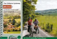
The Chilterns Cycleway is a 170 mile circular route passing right around the Chilterns Area of Outstanding Natural Beauty. Over 95% of the route is on-road (mostly following minor roads), with just a few sections following towpaths, surfaced cycle lanes and bridleways.

Cyclists with slick road-bikes should be aware of the few unsurfaced sections which can be rutted and muddy and unsuitable for `skinny` tyres; cyclists can either push their bikes along these sections or follow an on-road alternative (suggested alternatives will be given in the guide book).

The Chilterns Hills are by definition hilly!! The route is undulating with some steep climbs and descents in places. This, combined with the fact that there are a few busy sections of road along the route, makes it unsuitable for novices. Cyclists will need a reasonable level of fitness and experience of cycling on roads with traffic. There are rides suitable for novice and family cyclists in the Day Rides section.

Kartenausschnitt

Kartenbeispiel

Chilterns Cycleway Radwanderführer (englisch) 53 S. - Spiralbindung - Chilterns Conservation Board
The Chilterns Cycleway - 170 Mile Circular Route through the Chilterns Area of Outstanding Natural Beauty - Ringbound
EAN / ISBN: 9780954524265
Preis: EUR 13.90

Dieser Titel ist momentan nicht lieferbar.
Produkt EUR Anzahl Bestellen
Chilterns Cycleway Radwanderführer (englisch) 53 S. - Spiralbindung - Chilterns Conservation Board
The Chilterns Cycleway - 170 Mile Circular Route through the Chilterns Area of Outstanding Natural Beauty - Ringbound
13.90
Versandkostenfrei in Deutschland ab 30,- Bestellwert

incl. MwSt.

Stichworte, die bei der Suche nützlich sein könnten:
Chilterns Cycleway (Great Britain) Cycle Guide - Ipsden - Apsley End - Aldbury - West Wycombe - Sonning Common - Botley (Ley Hill - Wendover - Great Kingshill - Whitwell - Loosley Row - Studham - Henley-on-Thames - Chilterns Cycleway (Großbritannien) Radwanderführer - Great Offley - Ley Hill - Parmoor - Kinsbourne Green - Great Gaddesden - Amersham - Cookley Green - Stokenchurch - Botley - Berkhamsted - Harpenden - Breachwood Green - Großbritannien - Großbritannien Radwanderführer - Großbritannien Fahrradführer - Großbritannien Radführer

Zuletzt angesehene Artikel:

CoverChilterns Cycleway Radwanderführer (englisch) 53 S. - Spiralbindung - Chilterns Conservation Board
The Chilterns Cycleway - 170 Mile Circular Route through the Chilterns Area of Outstanding Natural Beauty - Ringbound

Cover1939 Dummerstorf Amtliche Topographische Karte 1:25.000 Landesvermessungsamt Mecklenburg-Vorpommern

CoverAuf Försters Wegen Die schönsten Berliner Waldwanderungen - von Wiehle, Thorsten - via reise

CoverEurasika Drei Kontinente - Zwei Fahrräder - Ein Abenteuer - von Daniela Schmidt und Tobias Klein - Esterbauer

CoverK342 Kasnäs Topographische Karte 1:50.000 EUREF-FIN (Maastokarttat) Maanmittauslaitos / Lantmäteriverket Finnland - ProjektNord

Cover1 Nederland Noord 1:200.000 - De sterkste fietskaart van Nederland - med veel Knooppuntroutes Fahrradkarte Niederlande Buijten & Schipperheijn

CoverBiosphärenreservat Bliesgau & Saarpfalz-Kreis 1:25.000 (Blatt 824) mit markierten Wanderwegen, Hütten, Radrouten - KOMPASS-Karten

CoverLago Maggiore - Lago di Varese (Blatt 90) 4in1 Wanderkarte 1:50.000 mit Aktiv Guide und Detailkarten inklusive Karte zur offline Verwendung in der KOMPASS-App. Fahrradfahren. Skitouren. - von KOMPASS-Karten

CoverZ01 Rijk van Nijmegem - Wanderkarte und Radwanderkarte 1:25.000 Falk - Niederlande

CoverVal di Sole - Val di Rabbi - Val di Pèjo - Val Vermiglio - Val di Bresimo - Maddalene - Presanella - Cevedale - Brenta Settore Settentrionale - Wanderkarte und Mountainbike-Karte 1:25.000 GPS (Blatt 17)
Carta Escursionistica e Mountainbike Casa Editrice Lagiralpina - Italien

Cover12-22 Melnik Topographische Karte 1:50.000 der Tschechischen Republik
Zakladní mapa Ceská republika - Cesky urad zememericky a katastralni - ProjektNord

CoverCykelkartan Blad 5 Blekinge Fahrradkarte Schweden 1:90.000 - Norstedts

Cover167 Chelmsford - Harlow & Bishop`s Stortford - Wanderkarte Großbritannien 1:50.000 LANDRANGER MAP - Ordnance Survey

CoverPlau am See, Malchow, Krakow am See und Umgebung - Radwander- und Wanderkarte 1:50.000 (Nr. 194) Ausflüge zwischen Hohen Wangelin, Dobbertin, Goldberg und dem Fleesensee. Radwander- und Wanderkarte, GPS-fähig. Wetterfest, reißfest. 1:50000 Dr. Barthel Verlag

Noch kein Cover vorhanden4955 Ostritz Topographische Karte 1:25.000 Messtischblatt des Deutschen Reiches - Preußische Landesaufnahme / Reichsamt für Landesaufnahme - Faksimile ProjektNord

Noch kein Cover vorhanden212.32 Amtliche topographische Karte 1:25.000 Polen

Noch kein Cover vorhanden4441 Bad Düben Amtliche Topographische Landkarte 1:25.000 (Präsentationsgrafik) - Landesvermessungsamt Sachsen

Noch kein Cover vorhanden243.32 Amtliche topographische Karte 1:25.000 Polen

CoverThe book of the Bivvy Cicerone (englisch)

CoverRepublik Udmurtien 1:100.000 Topographischer Atlas
Удмуртская республика - Топографический атлас FGUP Уралаэрогеодезия