| << Schottland << GroÃbritannien: Wanderführer + Kletterführer |
||
|
||
Zuletzt angesehene Artikel:
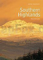
 | Southern Highlands Walking / Hiking Guide - Areas covered: Ben Lawers and Glen Lyon Fife and Kinross to Crieff and Callander, The Trossachs to the Mamlorn Hills, Loch Lomond and the Arrochar Alps to Inveraray, Hills of Crianlarich and Tyndrum - Nick Williams - POCKET MOUNTAINS LTD |
 | 0695 Gaidellen Topographische Karte 1:25.000 Messtischblatt des Deutschen Reiches - PreuÃische Landesaufnahme / Reichsamt für Landesaufnahme - Faksimile ProjektNord |
| 3276 Freitagsheim Topographische Karte 1:25.000 Messtischblatt des Deutschen Reiches - PreuÃische Landesaufnahme / Reichsamt für Landesaufnahme - Faksimile ProjektNord |
 | Nord-Seeland - Radwanderkarte 1:100.000 + Tourenführer (Karte wasserfest) Nordlige Sjælland - Cykelguide & Cykelkort / Northern Zealand Cycle Map & Cycleguide Nordisk Korthandel Dänemark |
 | 0324 GRAÃÃN Topographische Landkarte 1:50.000 Spanien (Grundlage MTN50) Instituto Geográfico Nacional - CNIG Spanien - ProjektNord |
| 1432 Westermarkelsdorf (Fehmarn) - Gestern und Heute - Historische Ãberlagerung 1932-1950 Topographische Landkarte 1:25.000 im Vergleich - Landesvermessungsamt Schleswig-Holstein / ProjektNord |
 | 99-1 CÃRNEAS Amtliche topographische Landkarte 1:25.000 Spanien (M.T.N.) 99-1 Mapa Topográfico Nacional de Espana (MTN25) Instituto Geográfico Nacional - CNIG Spanien |
 | 0228 VIANA DO BOLO Topographische Landkarte 1:50.000 Spanien (Grundlage MTN50) Instituto Geográfico Nacional - CNIG Spanien - ProjektNord |
 | Ãbersichtskarte Deutschland 1:750.000 - Wandkarte Poster 96 x 132 cm Planokarte - Bundesamt f. Kartographie u. Geodäsie BKG |
| 1931 Pelzerhaken - Gestern und Heute - Historische Ãberlagerung 1932-1950 Topographische Landkarte 1:25.000 im Vergleich - Landesvermessungsamt Schleswig-Holstein / ProjektNord |
 | 152 Mayrhofen - Zillertaler Alpen - Gerlos - Krimml - Tuxertal - Zell im Zillertal 1:50.000 - Wanderkarte / Radwanderkarte / Wintersportkarte Ãsterreich - GPS - Freytag & Berndt |
 | 0078-1 LA POLA Topographische Landkarte 1:25.000 Spanien (Grundlage MTN25) Instituto Geográfico Nacional - CNIG Spanien - ProjektNord |
 | 2733 02 Ristivaara Topographische Karte 1:20.000 (Maastokartta / Peruskartta / Grundkarta) Maanmittauslaitos / Lantmäteriverket Finnland - ProjektNord |
 | 0091 ELIZONDO Topographische Landkarte 1:50.000 Spanien (Grundlage MTN50) Instituto Geográfico Nacional - CNIG Spanien - ProjektNord |
 | 0142-1 AOIZ/AGOITZ Topographische Landkarte 1:25.000 Spanien (Grundlage MTN25) Instituto Geográfico Nacional - CNIG Spanien - ProjektNord |
 | 1042 LANJARÃN Topographische Landkarte 1:50.000 Spanien (Grundlage MTN50) Instituto Geográfico Nacional - CNIG Spanien - ProjektNord |
 | 0007-1 CEDEIRA Topographische Landkarte 1:25.000 Spanien (Grundlage MTN25) Instituto Geográfico Nacional - CNIG Spanien - ProjektNord |
 | 0069-4 VAL DO DUBRA Topographische Landkarte 1:25.000 Spanien (Grundlage MTN25) Instituto Geográfico Nacional - CNIG Spanien - ProjektNord |
 | N323 Kristinestad Topographische Karte 1:50.000 EUREF-FIN (Maastokarttat) Maanmittauslaitos / Lantmäteriverket Finnland - ProjektNord |
 | 1042-1 LANJARÃN Topographische Landkarte 1:25.000 Spanien (Grundlage MTN25) Instituto Geográfico Nacional - CNIG Spanien - ProjektNord |